December was a month of continuous grey with low cloud, mist and rain enveloping the landscape for much of the time. This encouraged me to stay close to home and limit my wanders with the camera to exploring the rocky shoreline of Loch Sunart within a mile or two of my home at Resipole. As you walk along the shoreline, the eye tends to get drawn to the expansive views of Loch Sunart as it curves through the hills of Sunart to its north and the hills of Morvern to its south. However, I found myself paying more attention to the rocks and boulders that were under my feet, capturing images of their curves and patterns, while contemplating on how they told me a story of how the landscape was formed and the immense timescales involved. Walking along the shoreline westwards from Resipole, in the littoral zone between the sea and the ancient Atlantic oakwoods, means picking your way over the countless rounded boulders. It is slow going, with eyes pointed downwards as you carefully move your feet from one boulder to another. However, as one footstep follows another, you begin to notice that what initially appeared to be a monochrome shoreline is actually full of colour. Blacks and greys gradually give way to the red and pink hues that are mixed in with them and you begin to realise that you are walking on multi-coloured parcels of geological time. Look closer again and you begin to find boulders with waves of white running through them, causing you to stop and consider the magnitude of the forces that were at play when these lines were formed, lines that speak of the area's dynamic volcanic past. However, it is a mile or so further west along the Loch, at the entrance to Sàilean nan Cuileag, where evidence of the forces and processes that shaped the landscape is particularly evident. The bare rock that lies there, between the sea and a blanket of heather and bracken, is a maze of twisted lines and fissures that speaks loudly of the Peninsula’s creation. It is awe-inspiring to think that these folds and grooves are physical records of immense forces and processes that were at play millions of years ago, when the now long extinct volcanic ring complex that formed Ardnamurchan was at the peak of its activity. However, it is perhaps the immensity of geological time compared to the brevity of human time that is more awe-inspiring. Geological time spans the 4.54 billion years of the Earth’s existence and dwarfs the mere thousands of years of human history. To comprehend this, consider that if the 4.54-billion-year timeline was represented by a 24-hour clock, then the entirety of recorded human history would fit into a mere 1-second sliver of it. Considering this, it is little wonder that while exploring these ancient formations, I felt a blend of curiosity, respect, and reverence for them. They are silent storytellers of Earth's geological past. Not only did they encourage me to photograph them, but they invited me to listen and reflect, capturing what I felt, rather than capturing what I saw.
2 Comments
I was away during the first couple of weeks of November, coming back with memories of some warm and sunny days on the beaches of Northumberland. This was a complete contrast to the cold weather that descended on the Peninsula shortly after my return. At first it brought cold, clear nights accompanied by bright, crisp days that were followed by a few days of snowfall, when snow found its way all the way down to sea level. This gave me an opportunity to capture some wintery scenes in the woodlands of Sunart. A favourite place of mine, Lochan na Dunaich, is just a couple of miles from the house. There is a lovely little trail that winds its way through the woodland there and this is where I headed to on the morning I awoke, opened the curtains, and saw the landscape covered in a fresh dusting of snow. The first part of the trail takes you alongside a dense stand of birch trees and on this particular morning its web of impenetrable branches was topped with a thin layer of snow. The snow was so finely balanced on them that it seemed like the slightest of movement would send it crashing to the ground. Thankfully, there was not a breath of wind, the slender limbs remained perfectly still and the snow, which was like powdered white sugar, clung to them, accentuating their form and allowing me to create a set of abstracts that portrayed the web of dark and tangled branches against a beautifully white backdrop. In amongst all this, were beech saplings, who had seemingly ignored autumn’s invitation to shed their leaves, defiantly holding on to them, almost as if to say that they were not yet ready for the onset of winter. Continuing beyond the birch trees takes you to Lochan na Dunaich, the ‘Little Loch of Sadness’, where a local tale has it that young children were lured into its waters by a Kelpie and never seen again. It is an inky black pool of water with fallen trees around its boggy edges, so you can well imagine this tale being used to warn children away from straying too close to it. Despite this somewhat disconcerting tale, I find the lochan to be an incredibly calming place. It sits in a natural bowl surrounded by tall trees and a steep hillside which shelters it from the worst of the weather. It was completely still on the morning I was there. Its surface perfectly mirrorlike, reflecting the surroundings in incredible detail. Surprisingly, it can be like that on the stormiest of days and on such days, a visit there can provide welcome respite from the turbulent drama of Loch Sunart, only a few hundred metres away. As autumn departs and winter arrives, the trees are left bare and the colours of the woodlands on the Peninsula shift from warm hues of red, orange and yellow to a muted palette that seems to be dominated by the russet of the undergrowth, the silver of the lichen and the mauve of the birch tree twigs. This is something I first noticed on a winter walk in Ariundle Oakwood about 3 or 4 years ago. With this in mind, I visited Ariundle a couple of days after my wander around Lochan na Dunaich, while snow was still on the ground, albeit a fair amount of it had shifted as a result of daytime thaws, which is a common feature of the temperate climate here on the Peninsula. The weather was mixed, with morning sunshine gradually disappearing as the sky greyed. While I made my way into the woodland, admiring an oak that always catches my eye as I pass it, a heavy snow shower swept in. A curtain of white descended from the slate-grey sky in a matter of minutes, with large, swirling flakes tumbling through the air, creating a veil that softened the trunk and limbs of this ancient tree. The snow began to ease as I continued my walk into the woods, with the curtain of white lifting to reveal distant birch and oak trees on the far edge of the scrubland to the south of the path. Pausing for a moment, I picked out two of these trees using a long lens while the last of the snowflakes dotted the air in front of them. Further on, a group of oaks stand on a mound that rises from the bogland that lies between the path and the Strontian River. I’ve photographed them a few times from various vantage points while they have been in leaf, but I have never been happy with the results. Undeterred, I decided to try again because their now skeletal forms seemed to stand out from the background more than they had done previously. Continuing into the woods, I came to a place where innumerable beech saplings have sprung up beneath the ancient oaks that cover the hillside there. Their slender trunks and delicate branches support a crown of orange leaves that seemed to glow like embers against the muted tones around them, serving as a reminder of autumn’s lingering touch amid the starkness of a winter that was fast approaching. It is here where I ended my photowalk, turned around and made my way back home to the warmth that awaited me.
Autumn seemed to really take hold in October, with the colour palette of the landscape on the Peninsula shifting to a mix of warm yellow, orange and red hues when the trees responded to both the drop in temperature and the drop in light levels. The expansive mix of woodland here provided ample opportunities to capture this change, with me spending my time in the woods of Moidart and Sunart photographing the varied colours of the birch, beech, rowan, larch and oak trees that can be found there. As is usual, I first noticed the onset of the change in colours when yellow appeared on the pockets of birch trees scattered among the oak woodland around my home at Resipole. The most prominent of these can be found in the field on the north side of the road to Salen, near the car park for Sàilean nan Cuileag, where a group of these trees stand out from a backdrop of still green-leaved oak trees that are always last to change colour. The light from the morning sun falls on them from the east and emphasises the twisted shapes of their silver-barked trunks which contrast against the golden backdrop created by the yellow and orange leaves that hang on them. In late afternoon, when the sun has moved around to the west, the trees are backlit and those silvery trunks now appear dark, almost black. However, the contrast of both colour and light means that they still stand out from the golden autumn foliage that surrounds them. You can also find groups of birch trees in the more shaded parts of the hillside, where darker and damper conditions have encouraged the growth of grey-green lichen that seems to drip from their branches. This lichen, usnea subfloridana, thrives on the acidic bark of birch trees and, for good reason, is known as 'old man’s beard'. Probably the most vivid autumn colour is the deep orange of fallen beech leaves and the woodland at Mingarry becomes carpeted in them at this time of the year. This creates a glorious display there, making it an ideal place to spend a couple of hours with the camera, especially when the morning sun breaks through the overhead canopy allowing dappled light to fall on the deeply coloured woodland floor. Allt nan Coinneal, or the Stream of Candles, runs parallel to a track that leads up through the beech woods to the ruins of High Mingarry and has a small waterfall part way up that I’ve passed countless times when walking the dog, but never stopped to photograph. However, on a dog walk this year, I noticed that the waterfall was scattered with golden coloured beech leaves, so I returned with the camera and spent an hour or so exploring it. I started with taking some wide shots of the whole fall using a patch of beech leaves caught in the rocks below it to anchor the composition, then changing to taking a series of close up shots of parts of it before finally leaving once I was happy that I had the images I was hoping for. Rowan trees seem to have been having a particularly good year, with their branches laden with a bountiful crop of bright red berries. I first noticed this on a walk down to Sàilean nan Cuileag when my eye was drawn to a swath of red berries and gold leaves that stood out from the dark, almost grey backdrop of trees that can be found on the western side of the bay. Why so many berries I wondered? Well, it seems that rowan trees are subject to a natural phenomenon known as “masting” where they produce heavy crops of berries in some years and far fewer in others. If you want to know more about this, do check out the recent blog titled “Witchwood” in the Frame of Mind section of my website. Rowan trees were believed to have the power to ward off evil and were often planted next to homes, barns, and cattle pens to protect them from malevolent forces, and this year’s bountiful bright red crop has drawn my eye to many old buildings that have this "Tree of Protection” as a guardian. One example of this is an old byre by the road between Strontian and Polloch. The reason for me being on the road to Polloch was to visit Loch Doilet because, at this time of the year, steep hillsides that cradle it are covered with large swathes of golden larch that contrast beautifully with the green of the pine trees planted alongside them. Given the narrowness of the glen there, I found that the best way for me to get a wide perspective of the contrast in colours was to use the drone, flying it both above the loch and up the hillsides on either side of it. When using the drone, I took some expansive shots of the view towards each end of the loch before focusing on a few abstract shots that emphasised the contrast between the green and gold trees. With the drone shots completed, I turned to my camera and using a long lens, picked out some more intimate details of the trees from my vantage point at the side of the loch, with the first being of a pair of green pine trees completely surrounded by the larch catching the last of the afternoon’s light before it disappeared behind the hills to the west of me. Next was a closer shot of a row of silver-barked larch tree trunks on the other side of the loch, beautifully topped with a band of gold pine needles. To end, I focused on the larch trees that were near me, zooming in to capture the detail of strands of golden needles hanging from their branches. The final tree species to focus on was the oak. They can be found across the Peninsula, either mixed woodland with other native species or in the remnants of the ancient Atlantic oakwood that covers a large part of the northern shore of Loch Sunart. They are always the last trees to change colour, but when they do, they produce an exquisite mix of yellow, gold and russet brown foliage to adorn their gnarled and twisted branches. A great example of this is on what is probably my favourite oak tree on the Peninsula, which can be found in the woodland near Salen. Although diminutive in size, it’s form seems perfectly balanced to me and it always catches my eye when I pass by it, no matter what time of the year. However, it is in late October that it is at its best, with vibrant autumn leaves shining out from the subdued woodland scrub that surrounds it. By the end of the month, the first of the winds of the winter storm season had stripped a lot of leaves from the trees and although this may be disappointing to some, it does mean that light can reach the floor of the deciduous woodland at Ariundle. When it does, the moss-covered boulders that can be found there are iridescent, giving off a lustrous and pearly sheen that changes in intensity as you wander through them. In such conditions, they seem magical to me and capable of harbouring mystical beings waiting to be unveiled. Indeed, the nearby village of Strontian derives its name from the mythological sídhe, a supernatural race comparable to the faeries or elves. In Scottish Gaelic, the village is called Sròn an t-Sìthein, which translates to ‘low round hill inhabited by the sídhe’, leaving me wondering if I had been under their watchful eye as I wandered through the woodland at the end of October’s photographic journey.
September is a month of change. It is the time of the transition between summer and autumn. With the sun lower in the sky, sunsets become longer and more intense and the combination of warm days and cool nights creates misty mornings. All of this provides fantastic conditions for landscape photography. In addition, settled weather can bring clear skies, which combined with longer nights can provide opportunities for night photography and capturing the Milky Way, which is at its most visible at this time of the year. This was certainly the case for the month just passed, when my photography focussed on sunsets, mist and the Milky Way. My photographic month started on a calm evening when promising signs of a sunset encouraged me to take the drive from Resipole over to Kinlochmoidart to see if I could capture an image that I had long had in my head. It was one that I hoped would show Loch Moidart from a different perspective. A perspective that places the viewer facing westwards out of Loch Moidart with Eilean an Fheidh as the main subject, but also including Riska Island and Eilean Tioram with its eponymous Castle. On arrival, the conditions were perfect. High tide had coincided with sunset and with no wind, the potentially muddy Loch Moidart was filled with completely still, sky-blue water within which Eilean an Fheidh and its associated skerries were nestled. As the sun dipped below the horizon, there was just the right amount of cloud above the western horizon to catch the pink, red, orange and yellow hues that were finding their way up into the sky. These colours bounced off the clouds and down onto the blue tinged mirror-like water that surrounded the islands. Two different images were created. The first was a single frame whose width I filled with Eilean an Fheidh and Riska Island, positioning the drone such that the distant Eilean Tioram and Castle Tioram could be seen beyond and separated from the vertical face of Sgriobaid Dubh on the mainland. The second was a 6-frame stitched panorama that gives a wider composition that also included the mass of Beinn Bhreac to the south of Eilean an Fheidh and the side of Shona Beag to its north. It was also wide enough to capture the Small Isles of Eigg and Rùm silhouetted against the orange glow from the sun in a gap beyond the northern side of Eilean Shona. A few days later, I awoke to a thin veil of mist over Loch Sunart and as I watched the colours intensify as the sun rose, I decided to go in search of mist over at Loch Shiel which, from experience, holds far more mist than Loch Sunart ever does. However, on reaching Acharacle, I found that Loch Shiel was almost clear of mist, except for a thin veil that I could see beneath the distant hills of Ardgour. The mountains were silhouetted against a sky that had been turned a deep, rich orange by the rising sun. After pausing for a moment to consider what to do, I decided to move on towards Dorlin and Castle Tioram with the hope of finding the mist I was looking for. Thankfully, the short drive to Dorlin paid dividends and took me to a landscape that was shrouded in mist. Looking southwards back to where the River Shiel meets the sea at Shielfoot, patches of mist drifted across the river and the low-lying ground to the west of it, while in the opposite direction, Loch Moidart was covered in a thick blanket of mist that obscured Castle Tioram from view. However, as the sun continued to rise, the mist covering Loch Moidart began to clear and Castle Tioram emerged from its soft white blanket while wisps of mist lingered over the island upon which it sits. The effect of this was to create a beautiful and mystical scene that was best captured from the air. The mist continued to clear and eventually Castle Tioram became visible from ground level, so I made my way along the shore towards it, eventually reaching a spot from where I could place it in the centre of the frame and capture both it and its reflection in perfect symmetry. The mist came and went, so I stood a while before pressing the shutter button at a moment when the castle was completely clear of the mist and the slightest of warm morning light was falling on its east facing walls. A satisfying end to a great few hours chasing Moidart’s mist. With the promise of some clear skies at night, I returned to Dorlin later that day for some astro-landscape photography. When I arrived, a bank of cloud was gradually moving north-westwards, leaving a clear sky behind it. Forever the optimist, I was hopeful that it was only matter of time before I would find myself under a clear, star filled sky. Before that though, I took time to capture some iPhone shots of the spectacular sunset that was enveloping Loch Moidart, watching its golden hues intensify before fading to blue and pink as the sun went down. Continuing to make my way along the estate road that skirts the edge of Loch Moidart I arrived at the subject for the image I had in my mind. It was a boat house that I’ve passed countless times while walking the dog and one which I thought would sit directly beneath the cloudy core of the Milky Way in the hour or so after dark during August and September. The timing was ideal because it was only a few days after a new moon. This meant two things. Firstly, there would be no moonlight to drown out the Milky Way, making it clearly visible to the naked eye and more importantly, the camera. Secondly, there was a high spring tide at about an hour after sunset, bringing the sea level up to cover much of the foreshore in front of the boathouse and simplify the composition. Whilst it was still light, I experimented with various compositions and, by using a compass to determine where the Milky Way would be when it was dark enough to photograph it, I settled on a composition that used the cobbled surface of the sea wall as the leading line to the boat house which I positioned in the bottom left of the frame at an angle that would see the Milky Way above it. By this time, it was about an hour after sunset and with the camera now fixed in position, I had about an hour to wait until it would be dark enough to photograph the Milky Way. It may seem to some as being a bit of a long wait, but this is the time I enjoy most about astro-landscape photography. With the camera set up and fixed in position you are free to simply enjoy the moment, to watch the stars appear one by one and to pick out the constellations as they gradually reveal themselves. It is in this moment that my thoughts often turn to consider how insignificant we are in the grand scheme of things. Consider this – our galaxy, the Milky Way, may contain 300 million potentially habitable planets and there are a total of 170 billion other galaxies in the Universe as a whole. With mind-blowing numbers like these, there surely must be the possibility of there being life beyond Earth. As the hour passes, I usually take test shots at regular intervals to check the light levels until I’m satisfied that it is dark enough for the camera to distinguish the Milky Way from its star filled backdrop and then, with one press of the shutter button I take my final shot, pack up and walk away satisfied that I’ve captured the image that I had in my mind’s eye.
In September of last year, I published a blog on this website titled Thin Places: Doorways to Other Worlds. In it, I explained how the use of the term “Thin Places” is used to describe places where the boundary between the physical world and a mystical, historical or spiritual world is believed to be exceptionally thin, thus facilitating a sense of connection between the two. In it, I named a few places around the Peninsula that felt “thin” to me, one of which was Bourblaige, a cleared settlement on the slopes of Ben Hiant. Since then, I have had it in my mind to spend some time there to connect with the place and am pleased to say that a couple of days there in August gave me the opportunity to do this. Bourblaige sits in a wide bowl beneath the south-eastern slopes of Ben Hiant, with the sea to its south, Camas nan Geall to its east and the road to Kilchoan to its north. It was from the road to Kilchoan that I made my approach, taking a well-defined farm track up over a short rise to a metal gate from which you begin to get views of the lower slopes of Ben Hiant and the ruins of Bourblaige itself. The track ends at the gate, so on passing through it, I then found myself picking my way over thick, uneven grassland and large areas of bog, down past a conical hill which has the remains of a pre-clearance sheep fank on it. Standing on top of this conical hill gave me a clear view across the 36 or so buildings that were the houses, barns, byres and small enclosures that made up the settlement. I paused there for a while and got my first sense of a connection with the past, with my imagination ignited by thoughts of who and what has been there before me. Foremost were reflections on the hardship and trauma that the people of Bourblaige must have suffered from being suddenly cleared from their ancestral homes by the landowner on a fateful winter day in 1828. Local accounts (Heritage Ardnamurchan and the Kilchoan Diary) say that the evictions were carried out with considerable cruelty with the displaced being forcedly marched to much poorer ground elsewhere on the Peninsula where it would have been even harder to eke out a living. Continuing over the grassland and bog, I made my way to a slight rise on the northern edge of the settlement and paused once again to take in the scene before me. It is from there that you begin to get an appreciation of the extent of the settlement, with a myriad of ruinous stone walls about a metre to a meter and a half high etching out the shape of buildings and enclosures that run from there, down towards the sea. Walking down from there, and through the various ruins, brought me closer to the sea and I began to consider how it may have played a part in the lives of the people who lived in Bourblaige and in the nearby settlements of Torr an Moine and Camas nan Geall. I reflected on how fishing may have supplemented the produce from growing crops and rearing animals as well as providing an essential transport link to other parts of the Peninsula and even the Isle of Mull, which is just across the water. As well as the proximity and the importance of the sea, I felt the looming presence of Ben Hiant, the long extinct volcano whose steep and intricately sculpted slopes seemed to provide shelter from the prevailing southwest winds for the entire settlement, and especially those buildings that are situated in the lower part of the wide bowl in which Bourblaige is cradled. The other thing that was ever-present as I explored the ruins of the settlement was the soft hiss of cascading water from a waterfall high up on Ben Hiant, about 600-800 metres away. Despite the distance, the sound of the waterfall continually drifted down the steep slopes of the mountain prompting thoughts of how water from its stream lower down would have sustained the life of the people who once occupied the land beneath it. Having explored the ruins in the top part of the settlement, my eye was drawn to two hillocks at the bottom end of it and under which more ruins were nestled. To me, these hillocks had the appearance of miniature versions of Ben Hiant because the folds and creases on their slopes were similar to those that are such a striking feature of the “Blessed Mountain” under which they sit. I made my way down towards them, carefully picking my way across grassy tussocks, water filled ditches, streams and bog. It was slow going, but the benefit of this was that my gaze was firmly downwards, allowing me to see not only where I could safely place each footstep, but also swathes of beautiful wildflowers that would have otherwise went unnoticed. Aside from the ubiquitous heather, I spotted white bog star, blue scabious, yellow tormentil and the russet orange seed heads of bog asphodel. Colours were also to be found on stones of the ancient walls of the abandoned buildings in the form of patches of lichen which stood testament to just how long the remains of the buildings have been standing exposed to the elements. Many of the top faces of these ancient walls were capped with vividly coloured red/green stonecrop as well as mosses whose colours ranged from bright green to grey-blue and provided me with the perfect opportunity for some basic macro photography. Further down the hillside, a gully runs eastwards and opens up views across the entrance of Loch Sunart, then the Sound of Mull and towards Ben More, the Isle of Mull’s highest mountain, which could be picked out on the distant horizon. The western side of the entrance to Camas nan Geall, in the form of Sgeir Fhada, was visible in the mid-ground. This rocky promontory is thought to the location of an iron age fort. Having reached the top of this gulley, I decided to begin to retrace my steps back up through Bourblaige. Turning around and looking back up the hillside I had descended gave me a completely different perspective of the settlement. The sea was now at my back and was no longer the dominant feature. Instead, large swathes of grassland beneath an expanse of sky gave the feel of not only wide-open space but also a sense of isolation or perhaps emptiness. These feelings seemed to build as I continued to walk up the hill, seeing many of the ruined buildings set against the cloud filled sky. Buildings that would have provided shelter for all the families for who this place was their ancestral home right up until they were cruelly evicted by in 1828 by Sir James Riddell the then owner of Ardnamurchan Estate. As I approached the last few buildings, I noticed well defined gaps in the walls of some of them. Gaps that would have been doorways into homes of the families, who would have eked out a living on this hillside, under the shadow of Ben Hiant. I couldn’t help but wonder if one of these doorways was the one referred to in an account of the Bourblaige clearance written in 1892:
“In one case a half-witted woman who flatly refused to flit, was locked up in her cottage, the door being barricaded on the outside by mason-work. She was visited every morning to see if she had arrived at a tractable frame of mind, but for days she held out. It was not until her slender store of food was exhausted that she ceased to argue with the inevitable and decided to capitulate.” Finally, as I left, I tried to comprehend the hardship and trauma that the people of Bourblaige would have suffered when they were suddenly evicted in the middle of the harsh Highland winter, seeing their homes destroyed, their animals shot and then forcibly marched miles across the Peninsula to a place where the land was poorer and eking out a living would be even harder. This abandoned and isolated place certainly is somewhere that the boundary between the physical world and the historical world is exceptionally thin. A place where you find yourself picturing scenes from the past as if they were unfolding right before your eyes. As is usual, July was a slow month for me photographically and I guess this is down to the harsh light that you tend to get at that time of the year. However, I did make some trips out with the camera to Ariundle Oakwood, Glen Moidart and Ardtornish Estate. The first two were more walks than anything else, with the aim of finding some places to photograph when the softer light of autumn arrives, while the purpose of the trip to Ardtornish was to complete some photography work I’ve been doing for Ardtornish Estate. While there I took the opportunity to do a little photography of my own and I this blog shows some of the images I captured. I arrived at Ardtornish on a dull afternoon. However, the forecast was for the rain to stop and the cloud to clear, so I was hopeful of some soft evening light and perhaps even some sunset colours. The cloud did clear for a while and this allowed me to do a little photography for the Estate, but sadly it returned and the dull conditions that had greeted me on my arrival returned. On the plus side, it was a calm evening with only a light breeze, the type of breeze that is just enough to keep the midges at bay, so it was most welcome. To take advantage of this and to make use of my time, I decided to fly the drone at the head of Loch Aline to see what shots I could get of Ardtornish House. The image above was from the drone’s first vantage point, above and behind Ardtornish House, looking down Loch Aline towards its entrance which has the village of Lochaline on its right and the Isle of Mull in the distance beyond it. If you look carefully, you can see Kinlochaline Castle in the midground to the right and an old boathouse on the loch shore to the left. These two buildings where the subjects of my own photography for the rest of the time I was there. Having taken some wide shots of Loch Aline, I decided to move the drone down lower and closer to Ardtornish House itself, photographing it from various angles, with my favourite image being the one shown on the right above. It was taken looking north-east over Ardtornish House with the high hills of Beinn na h-Uamha and Beinn Iadain catching the last of the evening’s sunlight in the distance. Ardtornish House is a rather magnificent Victorian mansion built by Valentine Smith in 1885-91. It replaced a more modest-scaled shooting lodge that was completed by his father, Octavius Smith in 1866 and had subsequently succumbed to dry rot. The original shooting lodge had a separate clock tower, which escaped the dry rot and stands on the hillside behind Ardtornish House to this day. The following day, I woke to clearing skies and morning sunshine, so I left early to take advantage of the conditions and complete the photography I was doing for the Estate. Once this was done, I spent some time photographing Kinlochaline Castle from different angles, using both my drone and my camera. The Castle is the former 15th century seat of the Clan MacInnes and stands proud at the head of Loch Aline. It had been uninhabited since 1690 until its owners decided to renovate the building into a family home in the late 1990s. The original part of the castle was a large, rectangular, 3 story space and during its renovation it was decided that the best way to create a living space and deal with problems surrounding re-roofing the building was to construct a one and a half story dwelling on top of the existing tower. On the shore of Loch Aline to the southeast of Kinlochaline Castle, sits an old, broad-eaved boathouse which was built in 1852-3 and was subsequently superseded later in the 19th century by a second boathouse further down the loch because it’s location meant that was of use only to the smallest boats at high tide. I had explored the boathouse the evening before, finding lots of interesting detail that I thought would be good to photograph, so I made a note to return to it the following day. When I returned, the mid-morning sun was lighting up its stone-built walls and slate roof so I spent some time photographing the gothic style windows, rusting steel wall retainers and the various ferns that had embedded themselves into the mortar in the walls. Inside the boathouse, you can find a high, point-headed boat entrance through which you can see Kinlochaline Castle over on the western side of Loch Aline. When I was there, the tide was just beginning to cover its gravel and mud floor and sunlight was being reflected off the water and onto damp stone walls and steps. Having finished exploring inside, I took a little while to sit on the wooden bench that can be found outside and took in the view down Loch Aline. All in all, this was the perfect way to end my exploration of this interesting little building.
After some lovely weather in May, which turned the woodlands around Loch Sunart that intense ‘spring green’ colour that featured in last month’s Viewfinder Vignette blog, things turned decidedly cold and grey in June. However, the wildflowers fought through the gloom to bring splashes of colour to places around the Peninsula and occasional breaks in the weather gave us one or two beautiful midsummer sunsets. The start of the month was particularly cold wet and grey, making it challenging for me to motivate myself to get out with the camera. However, my cocker spaniel Fergus needs walked whatever the weather and, more often than not, I take a camera with us when we head out on our daily wander. One walk took us to Sailen nan Cuileag, a bay to the east of Salen on Loch Sunart and while Fergus and his nose explored the shoreline, I sat on a rock, watched yachts leaving their overnight mooring in Salen Bay and took a few photographs of them as they were carried down the Loch by a light north westerly breeze.
As the days passed, the cold, grey and dull conditions persisted, so my outings continued to be limited to when Fergus and I were out on walks. One day, when we were at Kentra Bay at low tide, making the most of running about the vast sands (Fergus, not me!!) that appear when the bay empties, I spotted a lone sea urchin shell sitting amongst the sea pinks that cover the salt marsh there in June. I didn’t have my camera with me, so I made a mental note of the location and decided to come back in the evening to photograph it because the forecast was for the cloud to clear a little. However, when returned that evening, the clouds remained and the light that I was hoping for was not there. Nevertheless, I took a few shots of the sea urchin shell, some close up and some of the wider view before eventually deciding that my favoured composition was of it sitting amongst the sea pinks in the foreground with Ben Resipole under an imposing, cloud filled sky as a backdrop. The drive home from there takes me through Acharacle and past a tin shed that sits at the end of a croft field. It is something that I have driven by countless times, but on this occasion, a thick blanket of bright yellow buttercups that covered the field caught my eye and drew my attention to the contrasting colours of the tin shed. The sight of this beautifully colourful scene was most welcome on such a dull grey evening, so I turned the van around, found somewhere to park and took a few photographs of it. As the month progressed, one thing that has struck me this year was the number of foxgloves that were appearing. Their tall purple spires of bell shape flowers seemingly rising above every dense blanket of bracken that I have come across. Their size and colour make them visually striking plants and provide ideal subjects with which to anchor your composition and I used them for to this effect at Castle Tioram and Camas nan Geall. My final photography outing of the month took me to Samalaman Bay near Glenuig on an evening when the sun eventually made an appearance. To make the most of this, I decided to spend a few hours there to watch the tide go out and the sun go down. When I arrived, the sun was still reasonably high in the sky, so I focussed my attention on an upturned row boat that seems to have taken up a long term residence amongst the water lilies there. I started with wider shots of the boat and the bay with the jagged peaks of the Isle of Rùm in the distance before turning my attention to some close-up shots of the boat and the lilies. Worryingly, cloud began to roll in from the east as sunset approached but I remained hopeful that there would be a sufficient gap between the clouds and the western horizon to allow the sun to cast some light on the landscape. I wasn’t disappointed because eventually the sun dipped below the clouds and bathed the sands that had been uncovered by the falling tide with a beautifully warm and golden light. I photographed the bay and the sands until the sun dropped behind the Small Isles of Eigg and Rùm before taking a final shot of these islands silhouetted against an intensely orange coloured sky. I left Samalaman Bay satisfied with what I had captured and with the thought that this must be one of the best places on the Peninsula to experience a midsummer sunset. On the way home the following morning, I stopped off at Ardmolich at the head of Loch Moidart to photograph a vast swathe of cottongrass that had caught my eye on the drive out to Glenuig. This plant is actually not a grass, but a sedge and it thrives in acidic, waterlogged soil such as that found there. It’s distinctive white, fluffy seed heads covered the ground, providing me with plenty of photographic opportunities and a productive stop with which to end my last photo trip of the month.
May is one of my favourite months of the year because it is the month in which the landscape well and truly awakens from its winter slumber. This was certainly the case this year because the intense ‘spring green’ colour that is such a potent sign of new life arrived in its full splendour to adorn the woodlands at the top end of Loch Sunart during the first week of the month, compelling me to go out and capture a small piece of this beautiful and vibrant sight. My first outing took me to Phemie’s Walk near Strontian and to my favourite place in the woods there. It is a place well off the path where a stand of magnificent birch trees creates an almost cathedral like space and on the morning I was there, their leaves were backlit to create an incredibly iridescent canopy that covered the space around me and tinged the trunks and branches of the trees with a beautiful green hue. A couple of weeks later and the leaves on the ancient oak trees that cover the hillside around my house at Resipole had well and truly made their spring entrance as well. This, along with the greening up of the previously dry and russet scrubland, had turned this part of Sunart into a verdant oasis and provide me an opportunity to use the drone to capture the ‘spring green’ from a different perspective. After capturing the panoramic view of the verdant oak trees that cover the hillside to the west of the house and Ben Resipole, I turned the drone to face the other direction down to Loch Sunart and the rocky shoreline down to where the oakwood stretches. It was late in the evening and some beautifully soft light from the low Sun was such that it accentuated the shapes of the trees to provide the perfect opportunity to take some top-down shots showing the interplay between the oak wood, the rock and the sea. One of the things that always fascinates me, when I’m flying the drone above the oakwoods with the camera facing downwards, is how distinct each of the trees can be. When you’re on the ground looking up through the tree canopy it seems to blanket the entire sky, yet looking down, reveals gaps and lines where the trees seem almost afraid to touch each other. This is a phenomenon called ‘crown shyness’ which is thought to be caused by the trees detecting a frequency of visible light called far-red light, which can tell them how close they are to their neighbours. When they sense they are close, they stop growing and thereby maintain their exposure to light and optimise the process of photosynthesis. I had a second outing with the drone in the hope of capturing more soft evening light on the trees, but this time around the bay that is Sàilean nan Cuileag, a mile or so east of Salen. However, despite the conditions looking hopeful, cloud rolled in from the northeast meaning that I had to content myself with a couple of shots of the bay that were more subdued that I had envisaged. Both images show the bay at high tide, filled with seawater and therefore at its most attractive for ariel photography. The first is looking out of the bay, southwest down Loch Sunart, while the second is looking northeast into the bay and back towards Ben Resipole and is perhaps my favourite image from the month, probably because I feel it captures so much of a place I’m lucky to be able to call home.
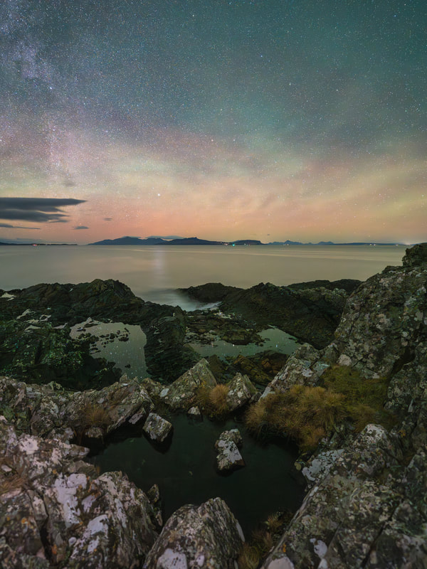
Photography is not always about taking photos and April was a case and point. I spent a large proportion of the month off the Peninsula, so only managed to get a couple of opportunities to be behind the viewfinder and unfortunately, they did not yield much that I was happy with. Fortunately, I was able to find time to sort through, sequence and edit a set of images that I had taken on a bright spring day last year when I visited the abandoned crofting township of Glendrian at the west end of Ardnamurchan. It is a fascinating and somewhat poignant place to be. It is a “thin place” where you can feel a heightened awareness of being very close to the past while you wander through the ruins of its abandoned buildings, the last of which was vacated in the early 1940s. 
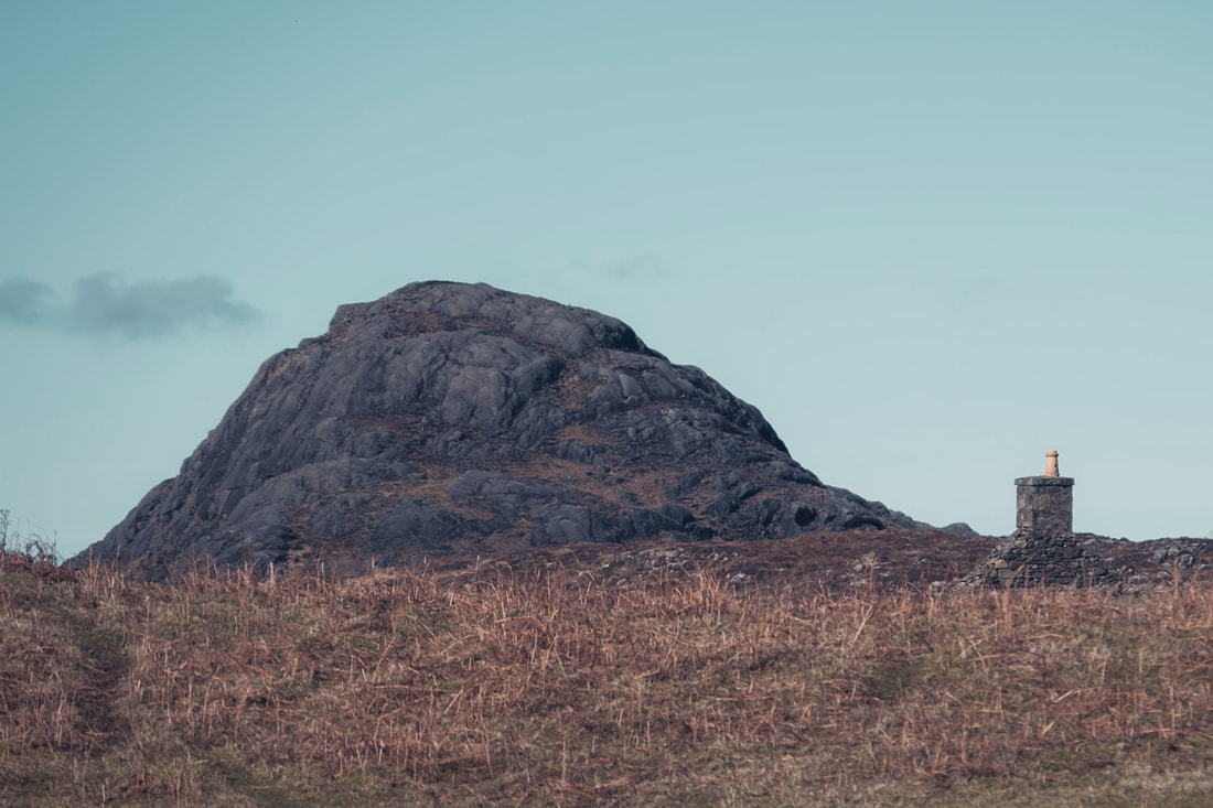
Glendrian sits on the low land within the circle of hills that form the crater of the long extinct volcano that you drive through on your way to the beach at Sanna. It is about 2 kilometre walk from where you park and the first part of the walk takes you up a short uphill section at the start of an estate track that leads all the way to the settlement. At the top of this short climb, you pass through a kissing gate and from there, the view opens up to the east and you catch your first glimpse of some of the houses sitting beneath the hulking black rocks that form the ring dyke of the volcano. 
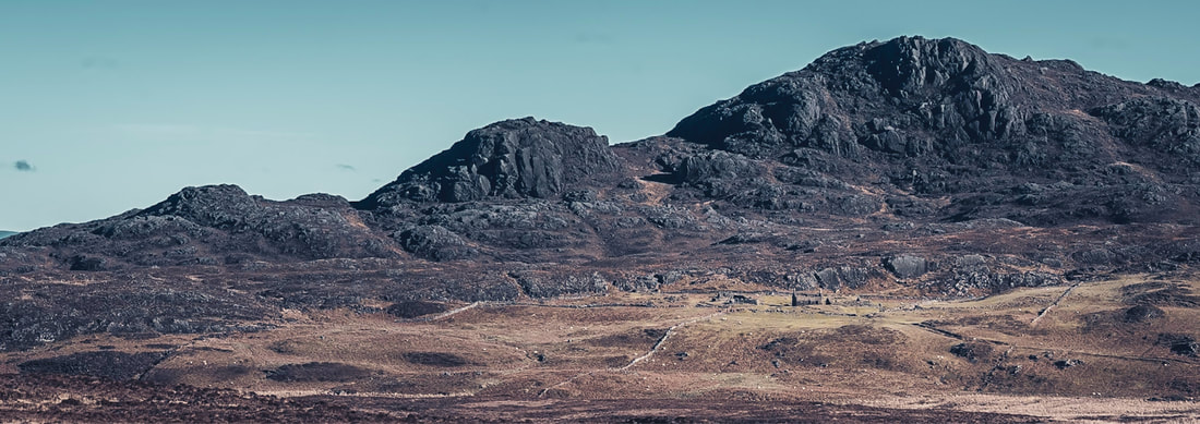
These houses are part of a settlement that is made up various structures, from small round cornered buildings with only one or two windows, through to more substantial gabled buildings with chimney pots and harled exteriors. They are scattered across a large area running roughly south to north along the eastern edge of the ring dyke and, as you wander around them, you often catch glimpses of the sea, which is about another 2 kilometres beyond the settlement. 
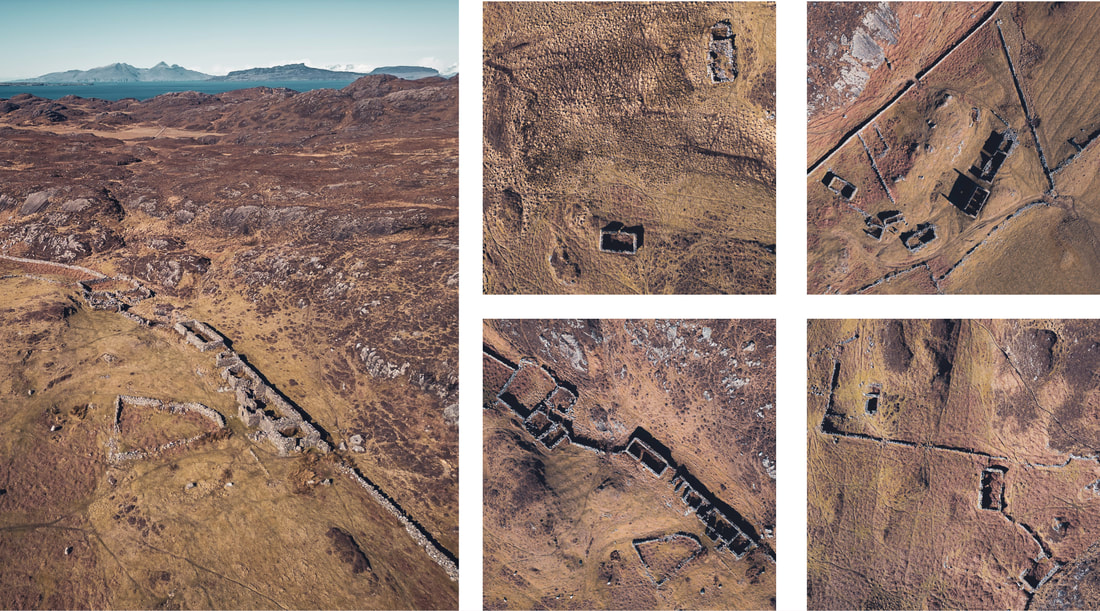
As you get close to the first of the houses, you cross the Allt Nead an Fhìr-eòin, a small river which I assume was the main source of water for those who once lived there. It is such a quiet spot and I found myself sitting there for a while watching the sunlight dance across the rocks beneath the rippling water. 
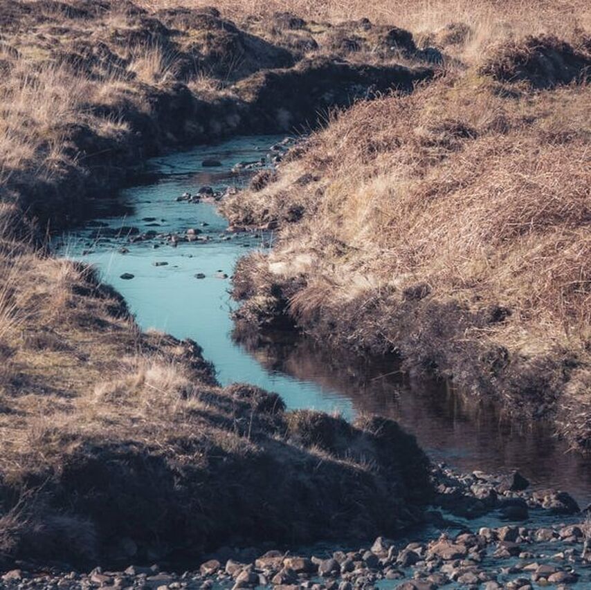
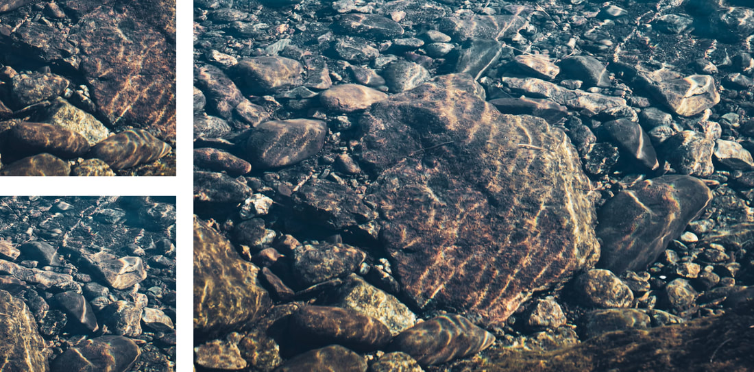
The first group of houses, located at the southern end of the settlement, are the most modest and appear to be the oldest. Some sit on their own, isolated in the landscape, while others are built into the hillside and have what look like small byres attached to them. 
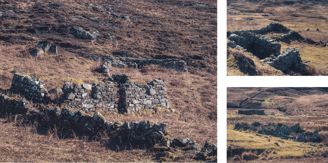
They are also the most ruinous of the buildings, which perhaps suggests that they were the first to be abandoned. Research suggests that this may have happened in the late 19th century when the smaller crofts at Glendrian were gradually merged together to form larger tenancies, resulting in the number of households dropping from ten at the time of the 1861 census to three at the time of the 1901 census. 
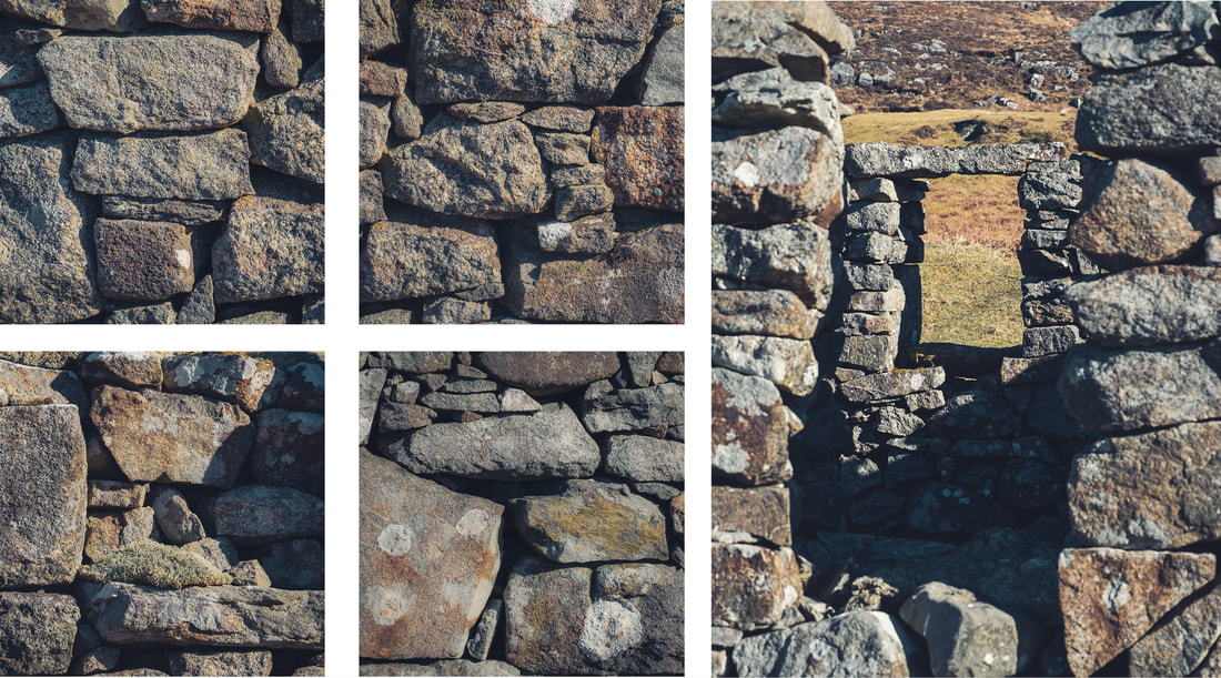
Unlike many of the old crofting settlements in the Scottish Highlands, Glendrian was not subjected to the brutality of the mass evictions of the “Clearances”. Instead, its population was gradually decreased by changes in land management practices, but despite this, it was incredibly poignant to sit on the hillside and watch sheep graze in a place where people once lived. A place that they once called home. 
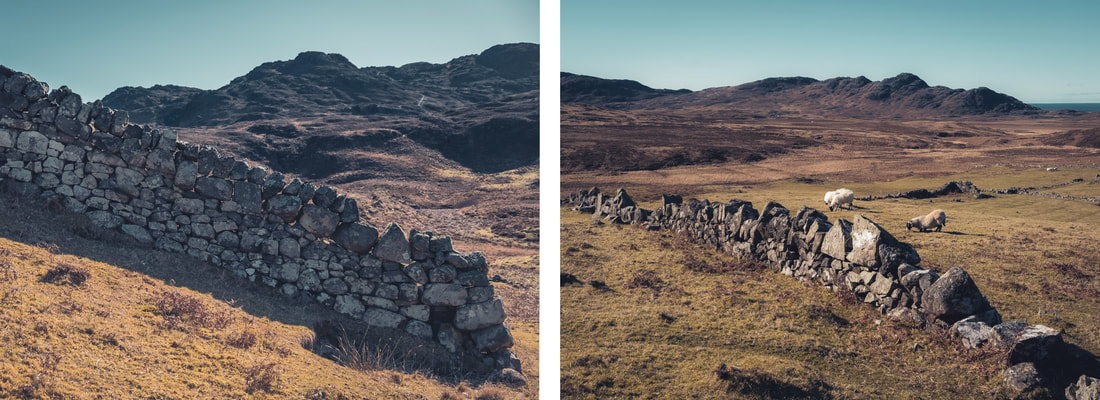
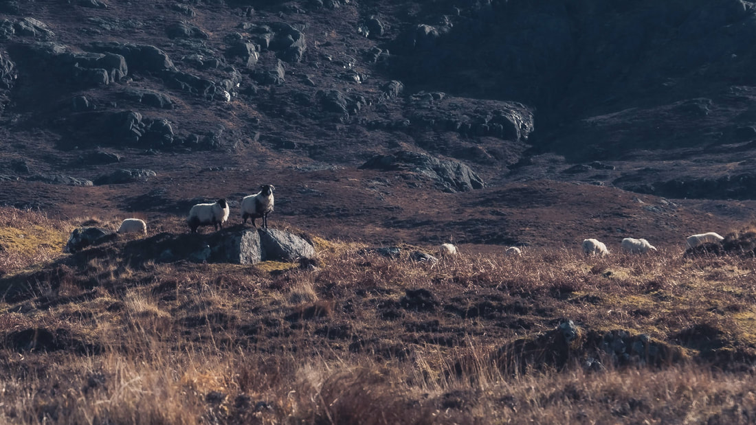
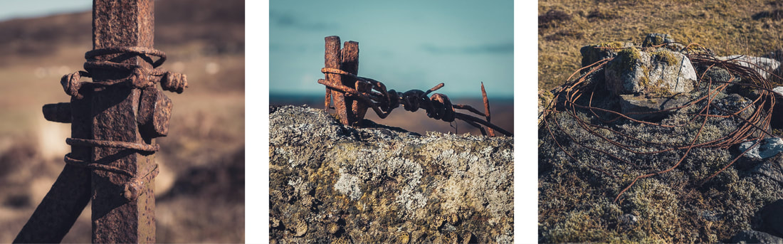
By the late 1930s, only two families remained. One of these families was the Hendersons, who occupied a terraced group of buildings that can be found mid-way along the settlement, high up on a piece of relatively flat ground at the base of the ring-dyke of the volcano rises upwards behind it. The buildings are more intact than those to the south, with the apexes of the gable ends of the croft house still standing and harling still visible on some of its external walls. Its last occupants, Donald and Mary Henderson, moved to Kilchoan shortly after their son Angus was born in 1940. 
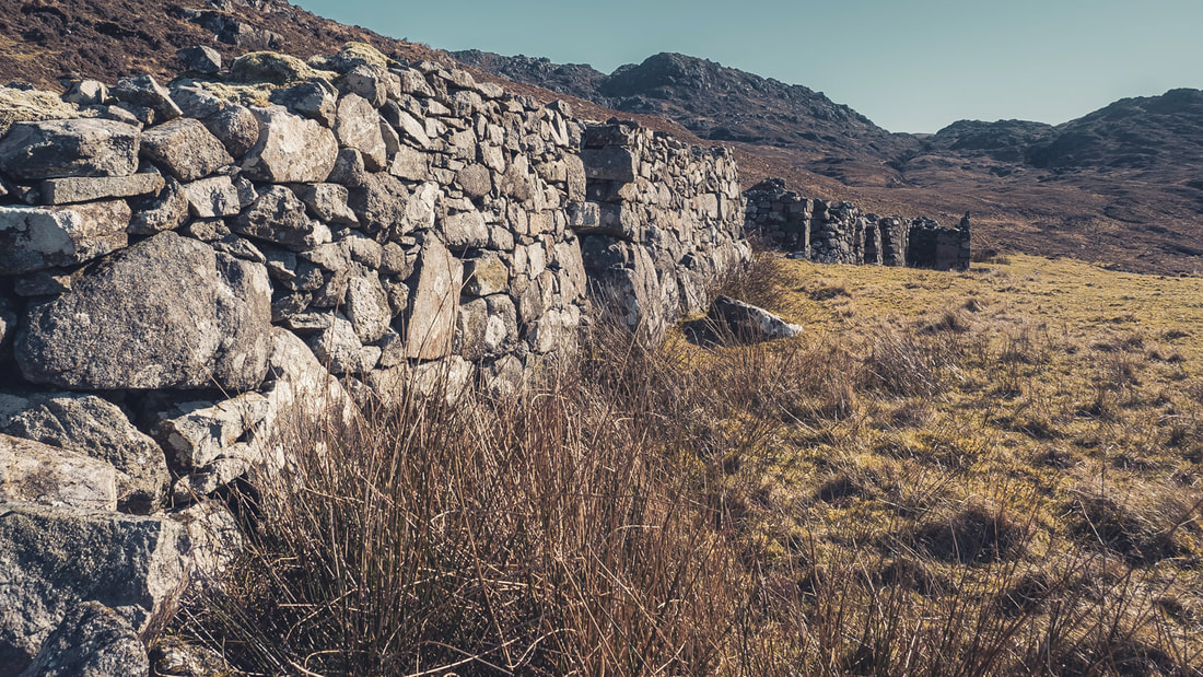
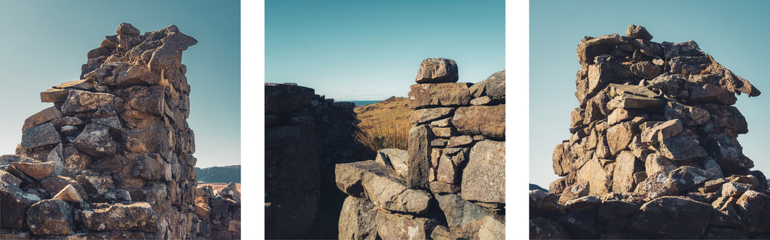
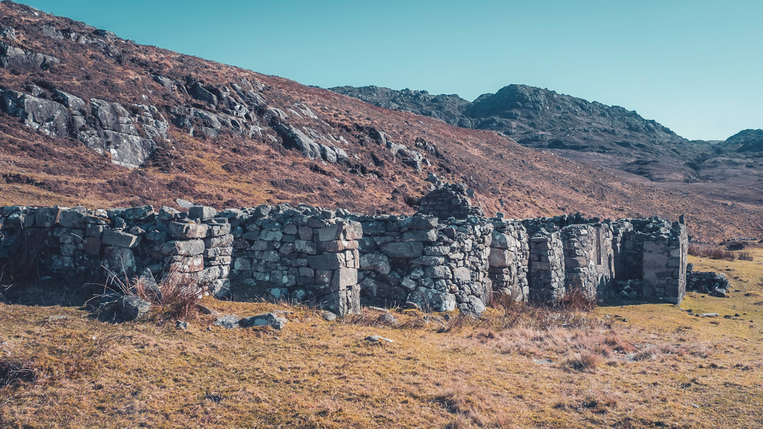
Below the Hendersons, lived the MacLachlans, who occupied what is the most significant building remaining in the settlement, a two-storey house which was built around 1871. Although basic by today’s standards, it was far better appointed than the other buildings in the settlement with its chimney stacks at each end serving three fireplaces. Two at one end, ground and upper floor, to provide heat and one on the ground floor at the other end for cooking. 
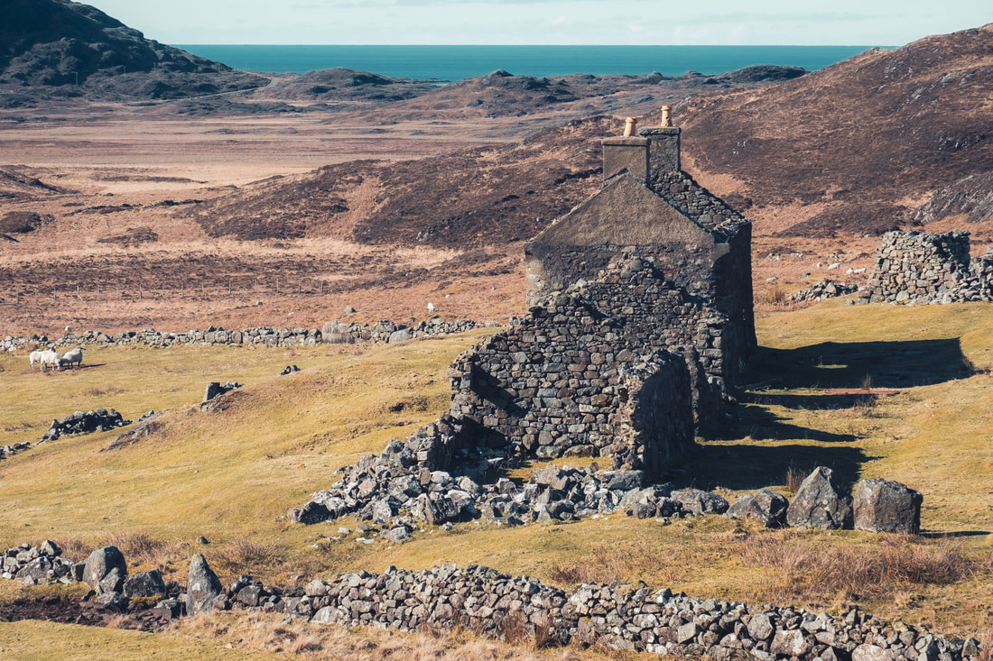
This “new house” was first occupied by Allan MacLachlan shortly after it was built, and its last occupants were John MacLachlan and his wife. John died in 1941 and his now widow moved to Achnaha to stay with her nephew, leaving Glendrian abandoned to this day. 
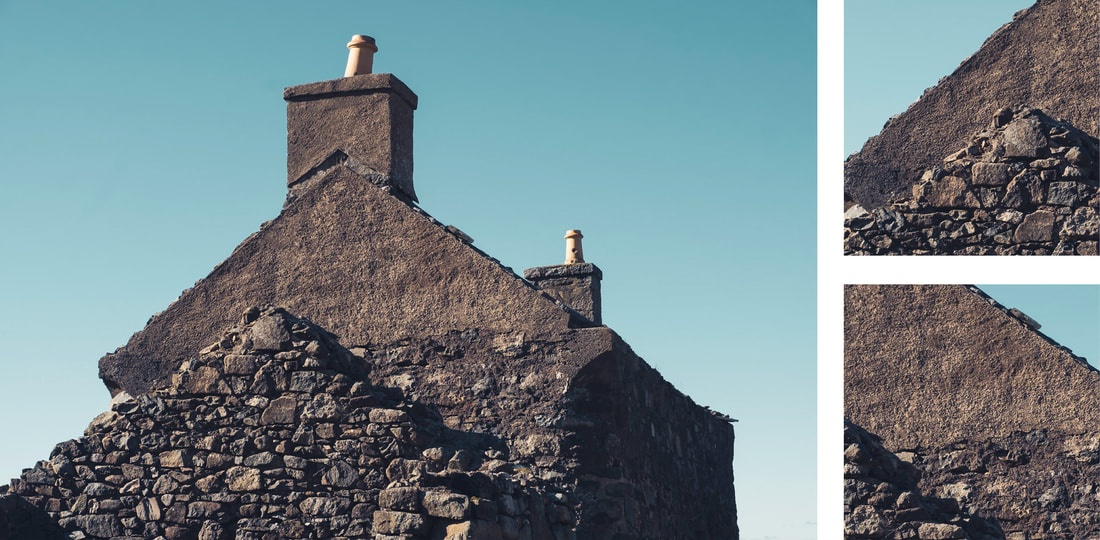
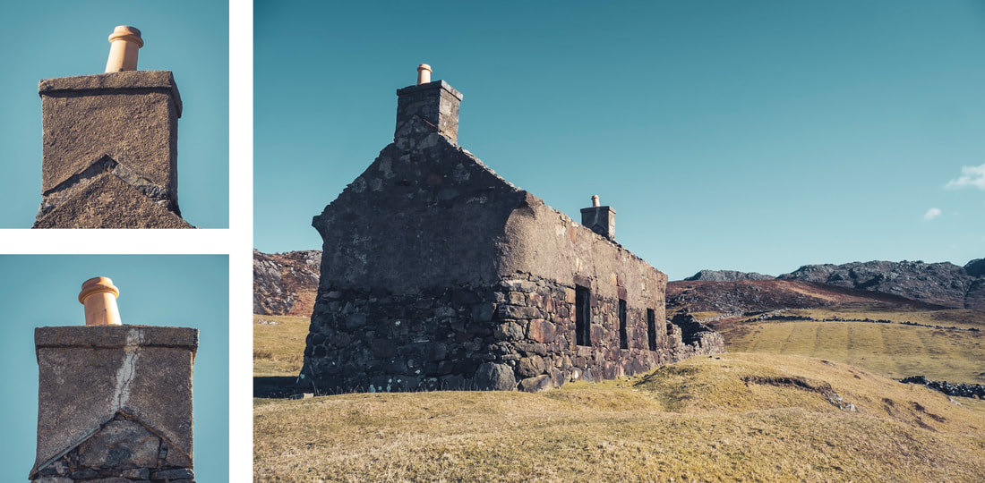
The house resisted the elements for a good number of years with its roof finally coming down during a storm in 1994 and one visitor reported that the upper floor remained in place until as late as 2009. Just over a decade later, there is not much left of anything that isn’t stone, with the doors, windows, floors and roof now long gone. All that remains are some fragments of the corrugated tin roof and some pieces of timber supports, all of which now lie on the ground on the eastern side of the house after presumably being blown there by the winds of that fateful 1994 storm. 
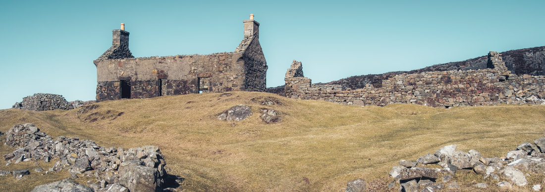
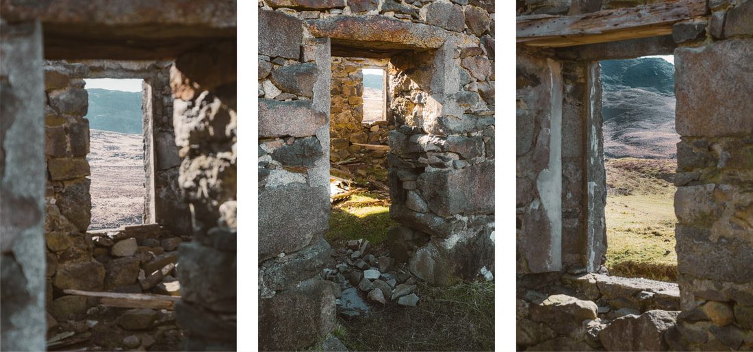
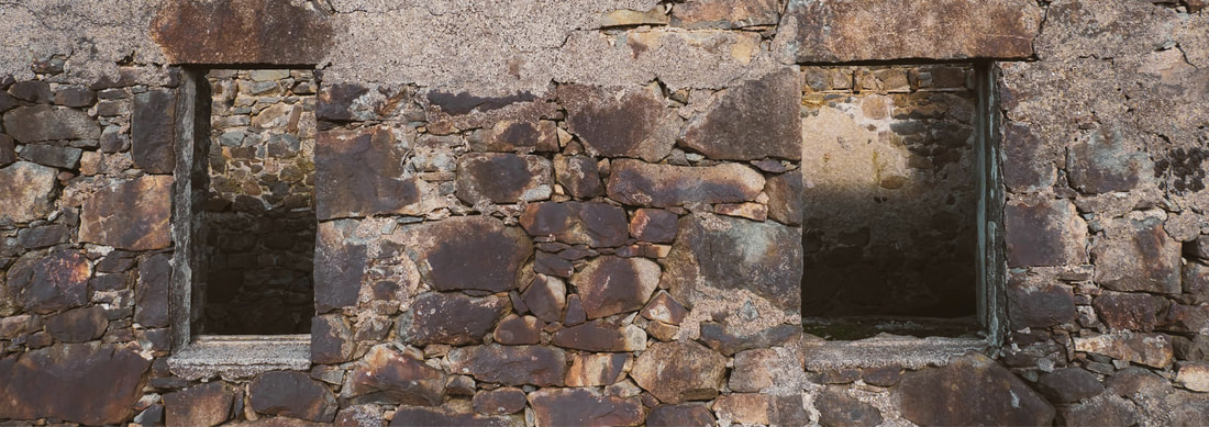
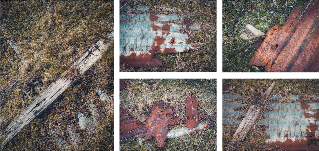
After photographing in and around the house, I explored the outbuildings that were attached to it, ending my visit by surveying the expansive view of the volcanic caldera from the elevated position that a once thriving community had occupied. While doing so, I began pondering on how the ruins of nearly twenty buildings remained following the 80 years over which the settlement was gradually abandoned and the just over 80 years since the last occupant left. While doing so, I couldn’t begin to imagine the mixture of emotions that the last occupant might have felt as they closed the door on their home for the last time.
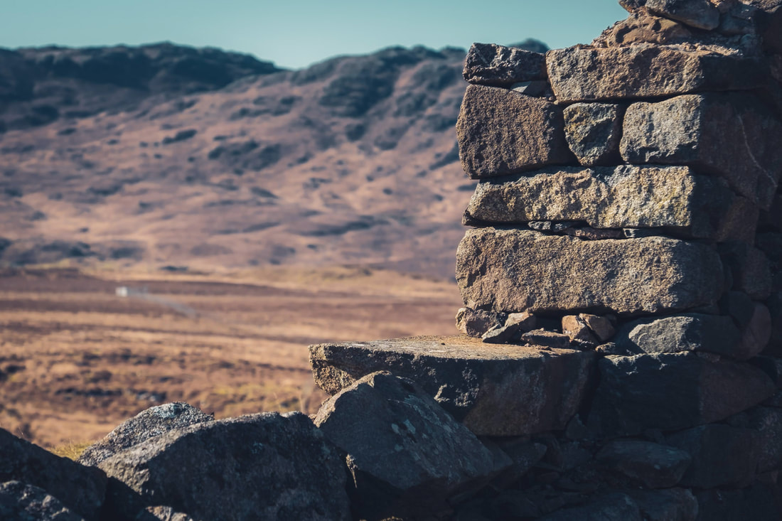
March was quite a busy month photographically, with me visiting numerous places across the Peninsula from Portuairk right over in the west of Ardnamurchan; Fascadale Bay, Kilmory Beach and Swordle Bay on its northern coast; the River Shiel and Castle Tioram in Moidart; and then finally Kinlochaline over in Morvern. However, I’ve decided here to focus on images from two visits that I had to Fascadale Bay. One was at high tide and the other was at low tide, meaning that the nature of the place was very different on each occasion. 
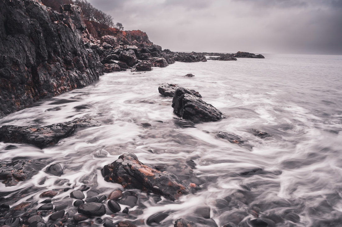
My first visit to Fascadale was on an afternoon at the start of the month when a high tide brought the sea well up onto the rocks around the sides of the bay. It was a dreich day and shower after shower of fine rain was blowing in from the hills that were to my back while I stood at the edge of the beach and watched the waves wash over a mixture of rounded stones and jagged boulders that made up the foreshore. 
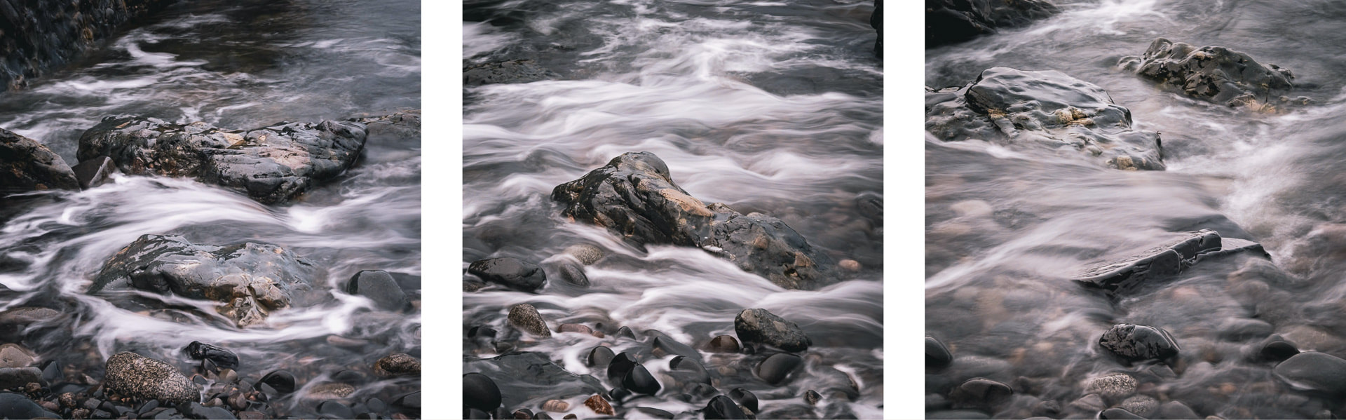
I stood there for a while, taking in the scene before me and listening to the sound of the sea washing over the boulders before deciding that the conditions were best suited to some long exposure photography. So, I headed down to the water’s edge, set up my tripod and took a few shots of the western side of the bay before pointing my camera downwards to focus on the water that was washing around my feet and the boulders I was standing on. 
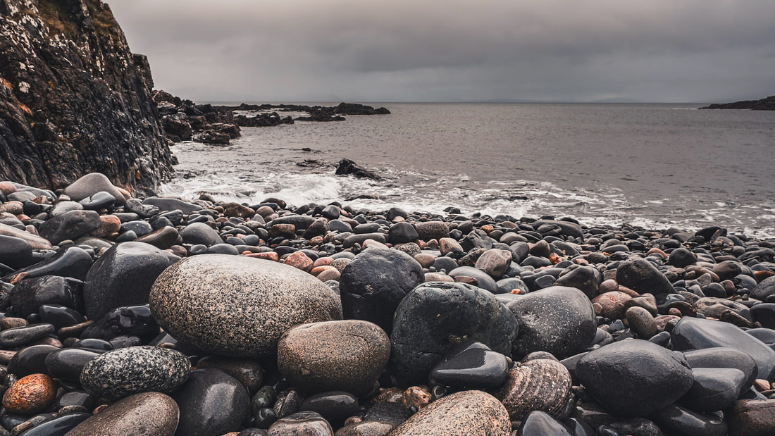
Satisfied with the shots I had taken, I packed up my tripod and filters, put my rucksack on my back and made my way up a steep bank of rounded boulders and away from the sea. Having kept my camera to hand, I took one final photograph of the bay, shooting low and wide to capture some boulders whose colours had been made vibrant by the rain that had soaked both them and me. 
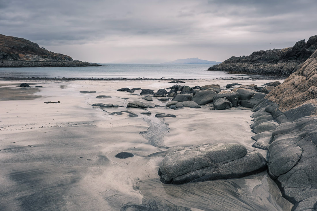
I returned to Fascadale Bay about a week later, but this time my visit coincided with low tide, rather than high tide. So instead of the sea washing over the boulders that it had been on my previous visit, it was gently lapping on light coloured sand that had been exposed by the receding tide. I walked along the edge of the sand next to the boulders, along to the eastern side of the bay and stood for a moment. Looking northwards out to sea, I could see the Isle of Eigg on the distant horizon and decided to take a photograph of it, using the rocks to the right to lead the eye out towards it. 
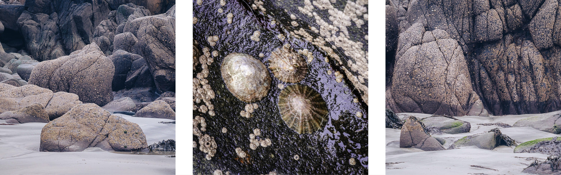
Before making my way down to the waterline, I turned my attention to the pink tinged rocks that were behind me and took a series of images of where they met the sand. When you first look at these rocks, they seem to be well rounded and smooth, but a closer inspection reveals a surface that has been made rough by the plethora of small limpets that covers them. 
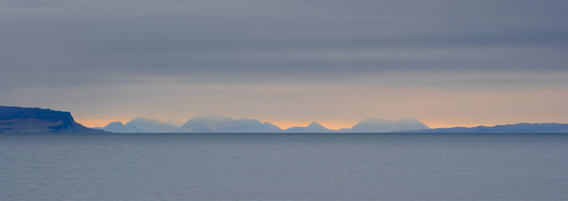
Having finished photographing the rocks, I turned back to face the sea to be met with the distant view of the Skye Cuillin. It was backlit by a warm orange glow and such an enchanting sight that was well worth capturing. 
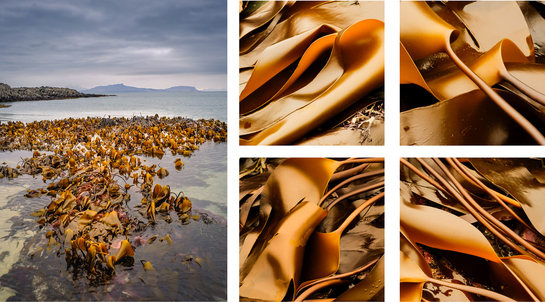
I eventually made my way down towards the sea with the intention of photographing the beautiful shapes that the peat and rock grains from the surrounding landscape had formed on their journey across the sand. However, I caught sight of a patch of kelp that had been uncovered by an exceptionally low spring tide and decided to spend some time photographing that instead. I wasn’t disappointed because both the colours and shapes were exquisite. It was as if leaves of gold had been placed in the water. 
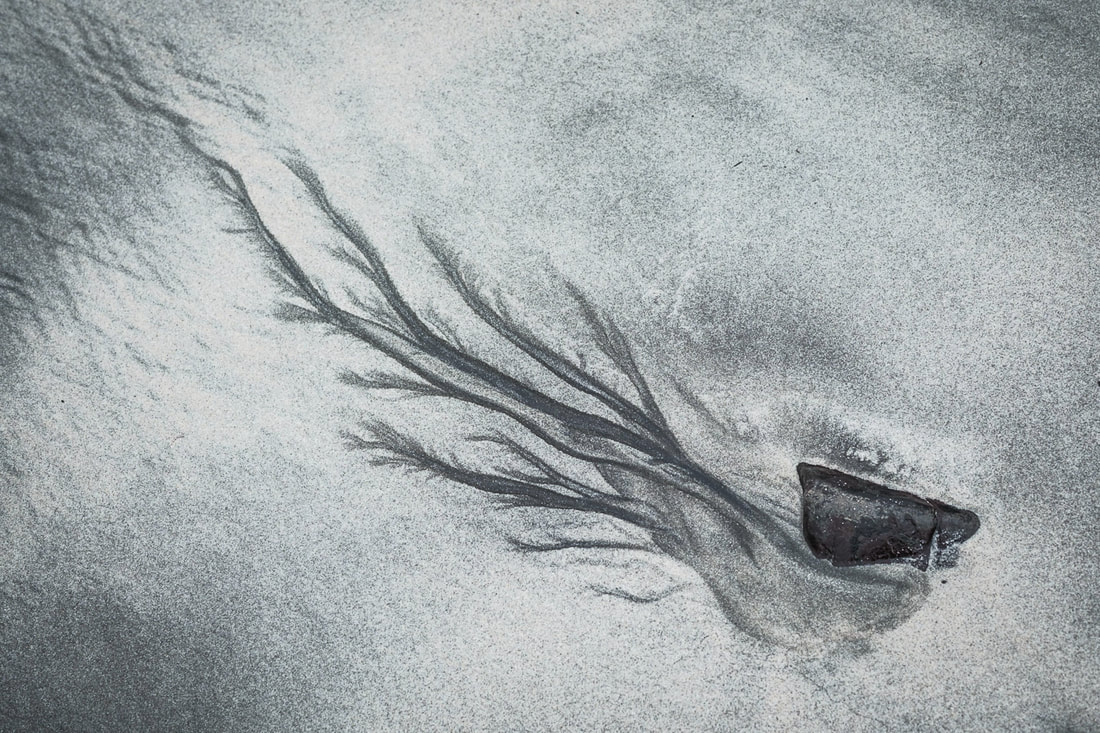
Finally, after photographing the kelp, I turned my attention to the ribbons and strands of peat and rock granules that had created intricate shapes that contrasted against the light-coloured sand. My first find was stone that looked as if it was the seed from which fine fronds of a plant had germinated. It’s amazing that dark granules of sediment being deposited by water flowing past the stone could create such a shape. 
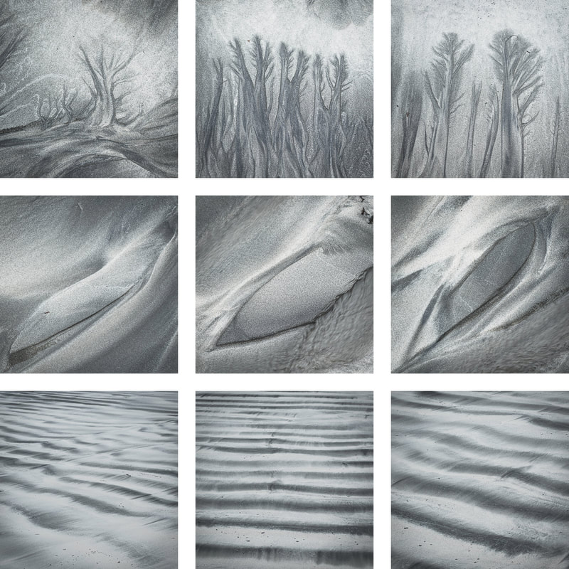
I continued to explore the beach, finding shapes that were reminiscent of small trees, shapes that were angular and geometric and then numerous light-coloured ridges interspersed with the troughs of dark sedimentary material. 
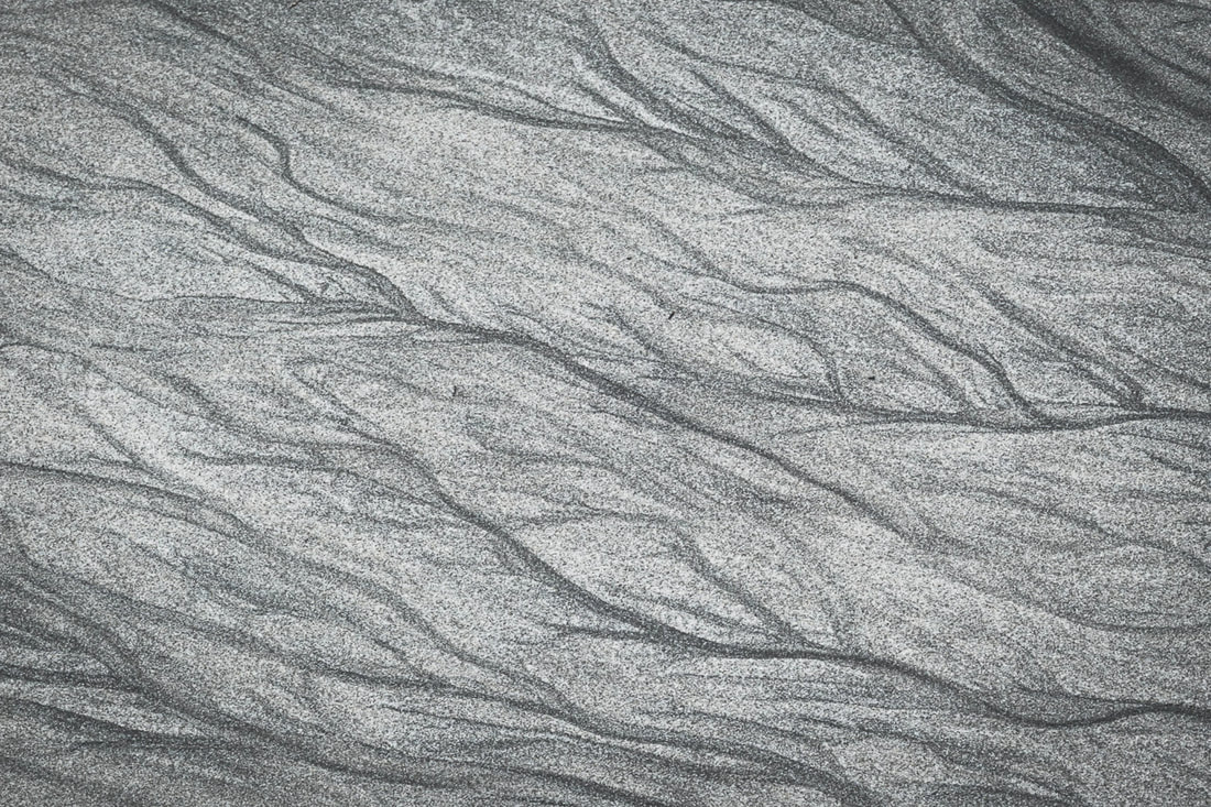
Before leaving the beach, I took one final photograph to capture a particular patch of sand that was covered in numerous veins of dark sediment that had been left behind by the falling tide. It was such an exquisite sight, and one that I felt compelled to capture, thus making it a fitting end to my time spent photographing what is an extremely small but feature filled part of Ardnamurchan’s northern coastline.
February, the last month of meteorological winter, proved to be less stormy than January but what it lacked in wind was certainly made up in rain. Looking at my weather station, it was the second wettest February I’ve experienced since moving to the Peninsula in 2016, with almost 200mm of rain in the month, and over half of that falling in the first week. The sheer volume of rain falling onto already saturated ground over such a short period of time meant that both the River Shiel and Loch Shiel were as high as I’ve ever seen them. I was keen to record this, so I headed up to the bridge that crosses the River Shiel just to the north-west of Acharacle to see what I could photograph. On the morning I was there, the rain had eventually stopped and the rising sun occasionally shone through the breaks in the cloud that were beginning to appear. This first image I took were of the bridge silhouetted against the warm morning light and I then turned my attention to picking out some of the trees downstream of it, that were sitting submerged in a few feet of water. 
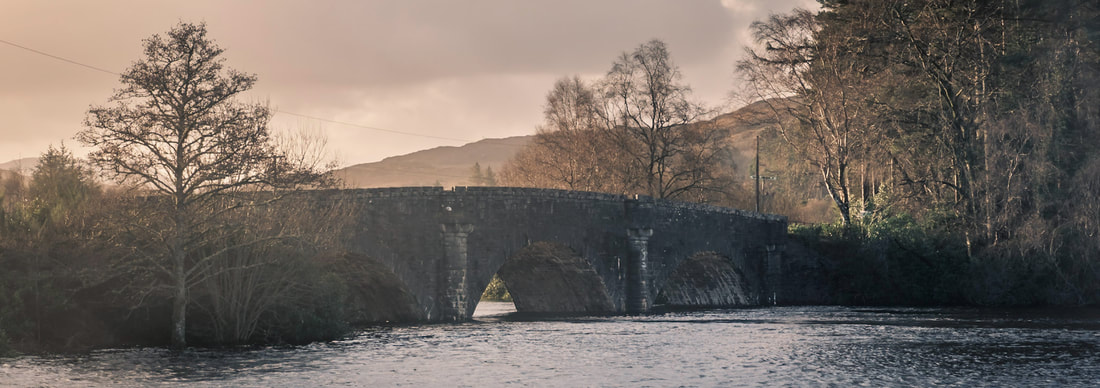
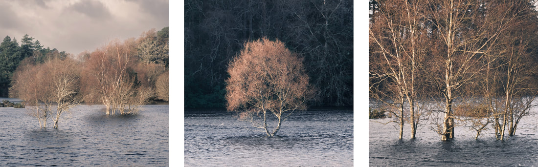
A couple of mornings later, I returned to Acharacle, but rather than photographing the bridge again, I decided to focus on Loch Shiel and the submerged fences that were in the flooded fields close to the Shielbridge Hall in the centre of the village. I was there just before sunrise, hoping for some colour to appear in the sky but high-level cloud cover prevented this and instead the landscape was bathed in some beautifully subtle, soft and warm light. This was perfect for the shots I ended up taking. 
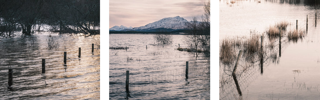
Upon finishing exploring the submerged fence posts, my attention turned to the various patches of ice that had formed along the water’s edge as a result of overnight sub-zero temperatures. Indeed, I was very appreciative of my liner gloves and woollen mitts, packed with charcoal hand warmers, which were keeping my fingers warm while the mercury still hovered around the -2°C mark. There were some fascinating wafers of ice suspended above the surface of the loch by tussocks of grass, presumably left because the water level in the loch was falling now that the rain had stopped for a couple of days. 
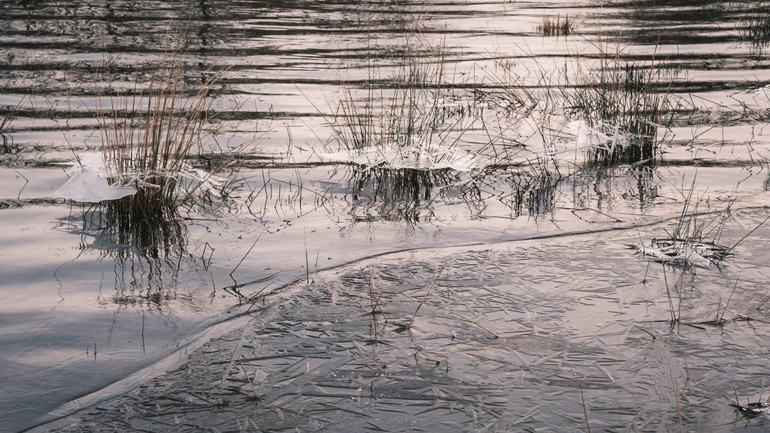
As well as these suspended wafers of ice, the curving water's edge near the Shielbridge Hall played host to a myriad of intricately frosted blades of grass that formed the boundary between the frozen field and the frozen loch. They were a joy to photograph. 
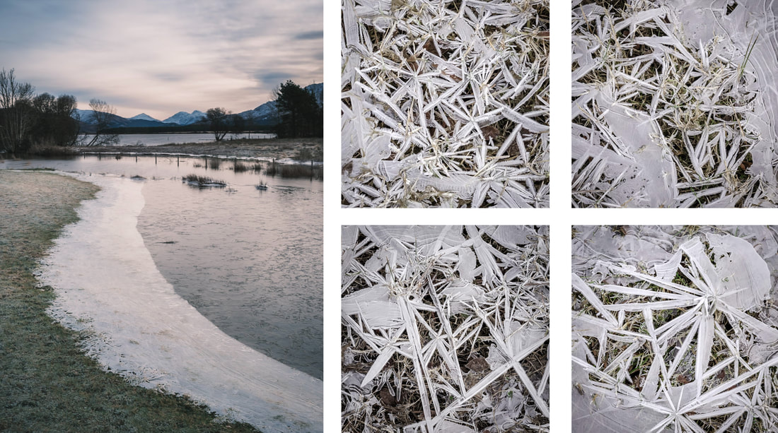
The middle of the month was dominated by misty, grey days which are best described as being “smirry”. You see, “smirr” is an Old Scots word for a delicate form of rain or a misty drizzle that lingers in the air and that’s certainly what we had. On days like that, woodlands are a good place to go for taking photos, so I decided to take my camera on a wander around the 4km loop at Ariundle Oakwood which takes you up the side of the Strontian River and back down through the ancient oaks that can be found there. 
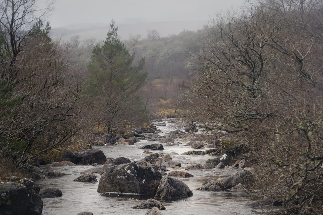
Despite the greyness of the day, there was still some colour to be found as my eye was drawn to the contrasts between the orange hues of the winter undergrowth, the purple tinge of the bare branches of stands of silver birch trees and the silvery grey of the lichen covered branches off the gnarly oak trees. 
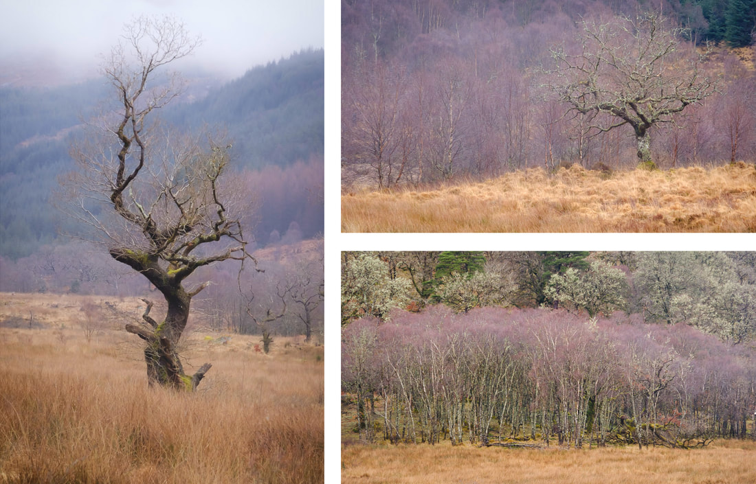
However, as always, the thing that catches my eye most when I take a walk through the oakwoods is the combination of thick and twisted oak tree trunks and branches surrounded by large and rounded moss covered boulders. There’s something quite enchanting about this sight and I think that it is little wonder that folklore has it that the boulders are home to faeries that live in the woods. 
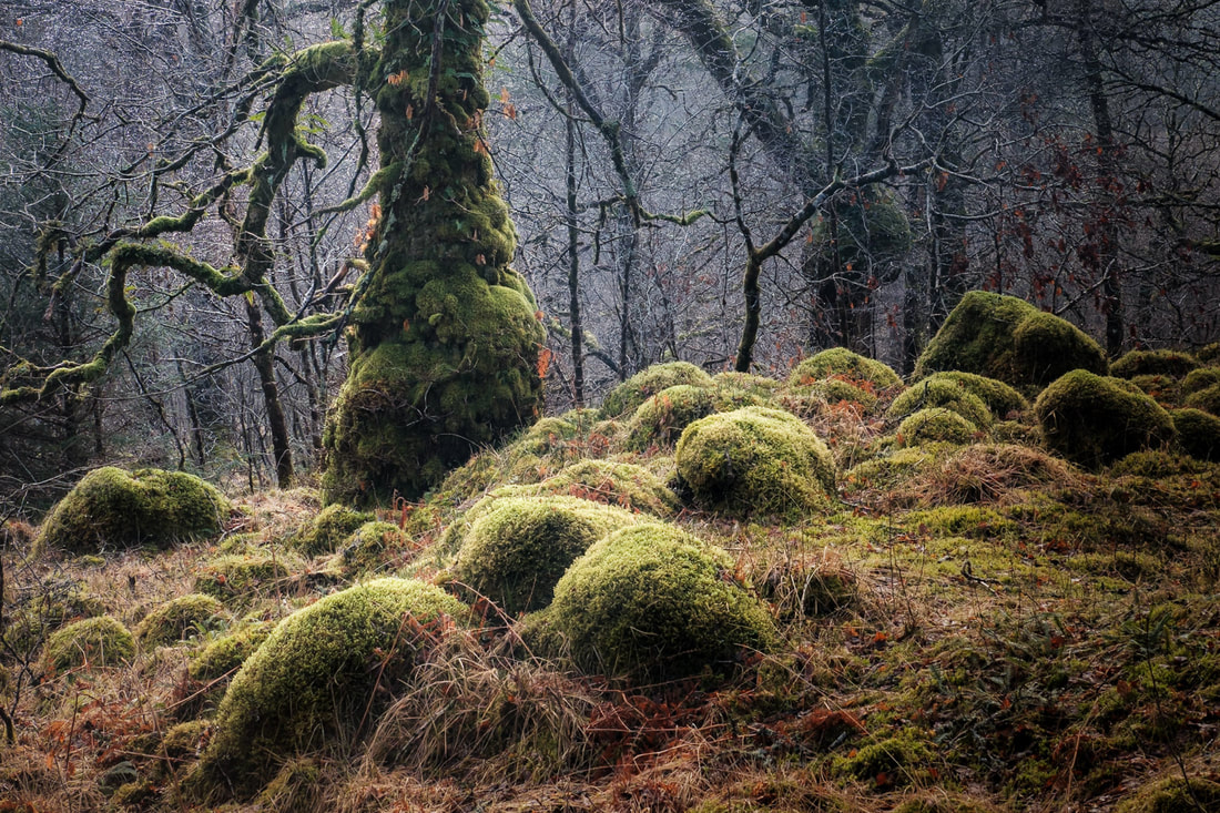
My next outing with the camera took me to Sàilean nan Cuileag, a small bay on Loch Sunart, just to the east of Salen. It’s not far from my house, so it is a place I often take the dog for a walk and on the countless times I’ve been there I’ve crossed a small stream that cuts across the path on the way down to the bay. I’ve never paid much attention to it but on this occasion, I stopped and spent some time taking some close-up shots of the water flowing over the red tinged stones that can be found in the streambed. I had never noticed them before, so the experience reminded me of what you can see if you take the time to slow down and really look at something. 
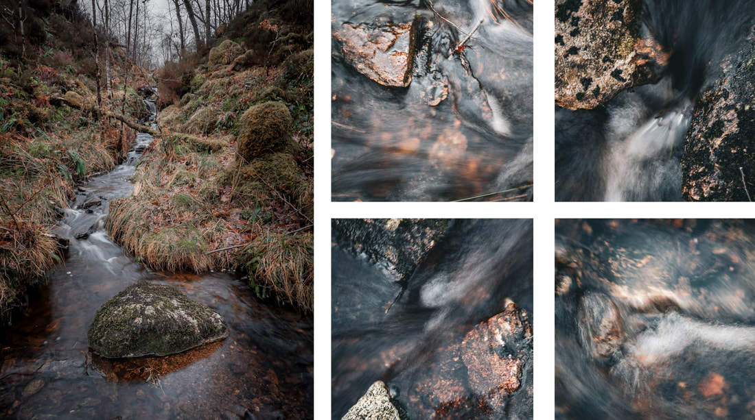
After photographing the streambed, I continued my walk down to the bay with the intention of photographing the stream as it flowed into the sea at high tide. I took a few shots of the scene I had in my mind, but the dullness of the evening meant that I didn’t get anything I was happy with. Instead, I turned my attention to taking some close-up shots of the trees that fringe the bay. They comprise a mixture of larch and oak, whose bare branches were covered with silvery grey lichen just like those I photographed at Ariundle Oakwood a week or so earlier. 
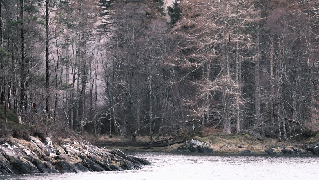
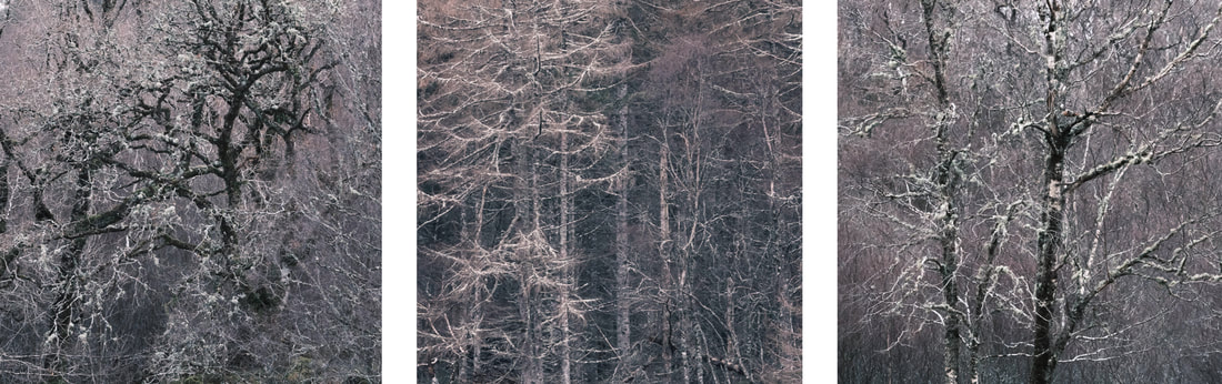
From all of the images above, you will see that February has been quite a grey and colourless month, but thankfully as both the end of the month and the end of meteorological winter approached, the weather began to improve and we were treated to a couple of colourful sunsets. During one of these, I was looking eastwards, out of the kitchen window, just as beautifully warm light fell on a snow capped Fuar Bheinn, a 2514-foot-high Corbett that is one of a horseshoe of peaks that circles Glen Galmadale over on Kingairloch Estate. 
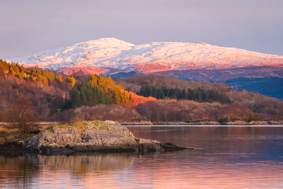
It was such a beautiful sight, so I just had to grab my camera, rush outdoors and capture the scene before the light disappeared as the sun dipped below the hills behind and to the west of me. After this, I stayed by the loch side for a while and watched the colours of the loch, sky and landscape change as the sun set and took the following image which shows the view looking westwards down Loch Sunart from Resipole. This rich orange glow of a late winter sunset was a perfect and spectacular end to a month, which for the most part, had been a dull and grey one.
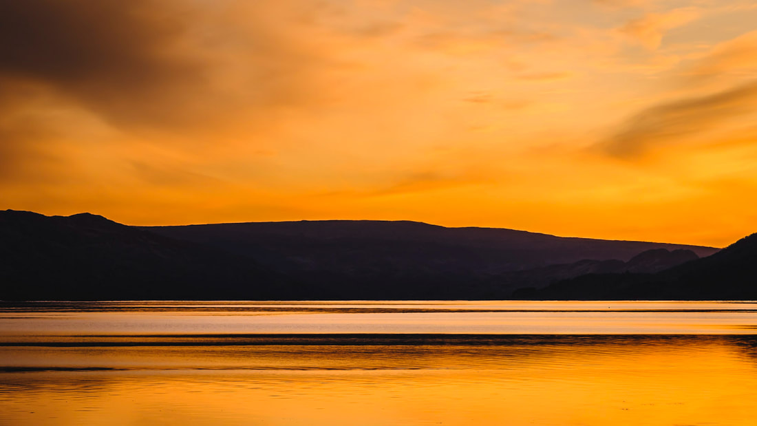
I’m sitting writing this while the wind is howling outside, the rain is battering off the window of my studio and the sea is being whipped up into a frenzy as yet more stormy weather passes over us here on the shore of Loch Sunart. This type of weather sure seems to have been a feature of the last few weeks, with us seeing no less than three named storms during January. We had storm Henk at the start of the month and storms Isha and Jocelyn at the end of the month. Of the three, Isha had the greatest impact on the UK with it being the most significant wind-storm to affect the UK since storm Eunice in February of 2022. However, for us here on the north-west coast of Scotland it was storm Jocelyn that felt to be the most severe, with wind gusts well in excess of 100 mph being measured in a number of places up this way. As well as these named storm days, there seemed to be many other days on which the weather was just a wild, so this limited the number of times I was able to get out with my camera during January. However, I did venture to the loch shore in front of the house during storm Jocelyn and managed to take the following image while struggling to stay upright as gust after gust attempted to lift me off my feet. 
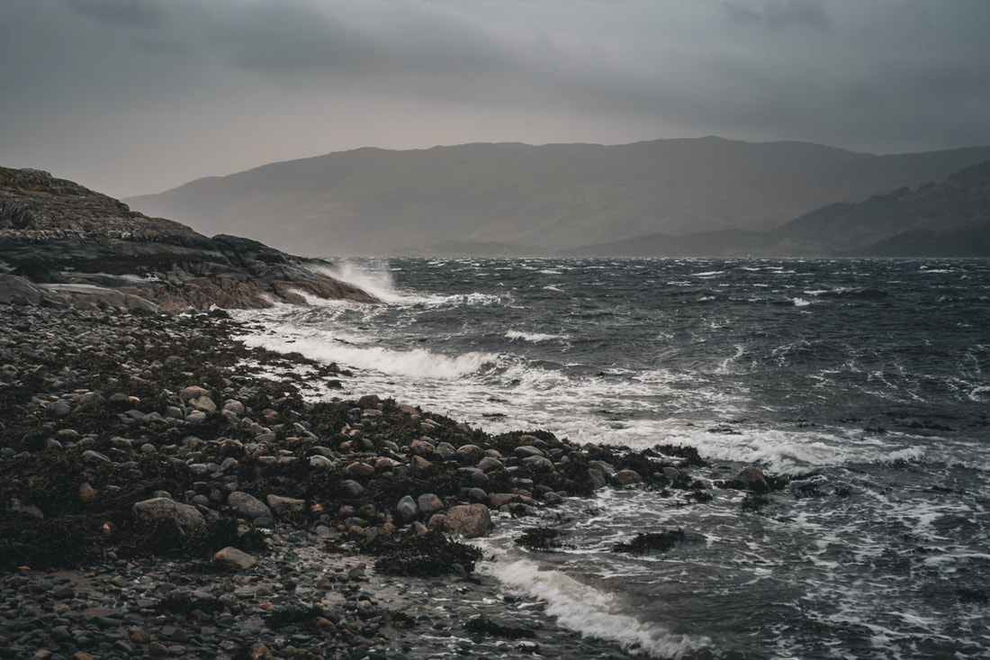
Thankfully, in the second week of the month, the sky cleared to bring a spell of extremely still and cold weather. The inordinate amount of rain that storm Henk had dumped on us meant that a layer of fresh water had settled on the surface of Loch Sunart, and it froze to form a layer of surface ice that ran from the head of the loch at Strontian all the way down as far as Glenmore where Ardnamurchan Distillery is located. 
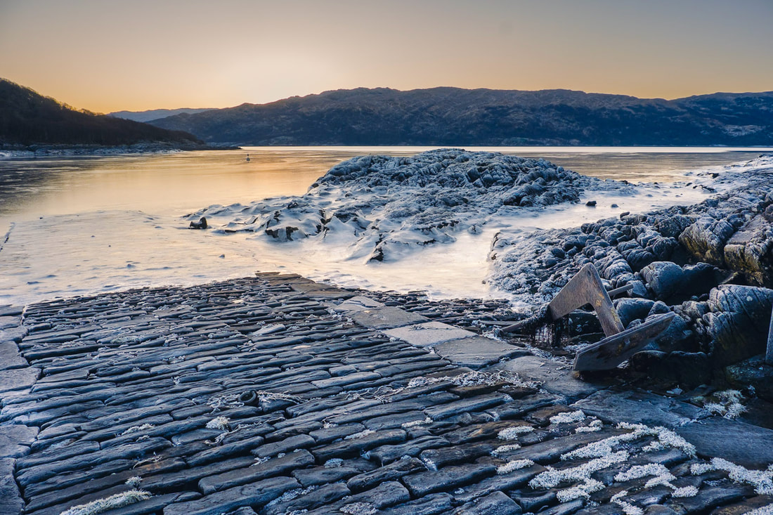
Having the loch freeze as it did is an extremely rare occurrence, so I decided to spend a few hours one morning to explore as frozen Salen Bay while accompanied by the sound of cracks and bangs from the ice as it shifted on the changing tide. I came away with a number of photographs, including the ones here, which were taken on and around the old stone jetty about half-way down the west side of the bay. 
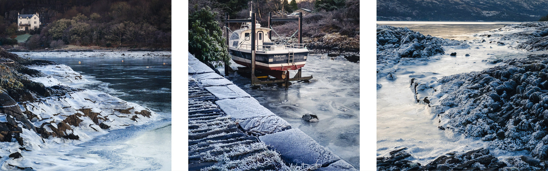
The ice had all but disappeared a couple days later and this allowed to safely walk out into Sàilean nan Cuileag, the smaller bay to the east of Salen Bay. It completely empties at low tide and is a place where I frequently walk the dog. When I do, I tend to take my camera because there is often something to photograph there and, on this occasion, I found a perfectly straight high tide mark where white hoar frost contrasted with the black rock that had been revealed by the falling tide. It was such an unusual sight and I just had to capture a few photographs of it before it disappeared. 
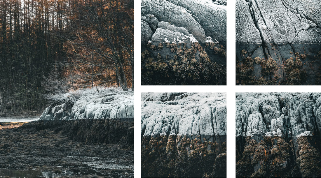
The cold, dry and settled weather lasted about another week before being brought to an end by some of very snowy weather when unusually, successive snow showers covered the loch shore with a white banket that lay all the way down to the sea after each successive high tide for about 3 or 4 days. Unfortunately, the amount of snow that kept falling meant that driving wasn’t to be recommended, so I had to content myself with some photography from the loch shore in front of the house and with some drone photography from above it. 
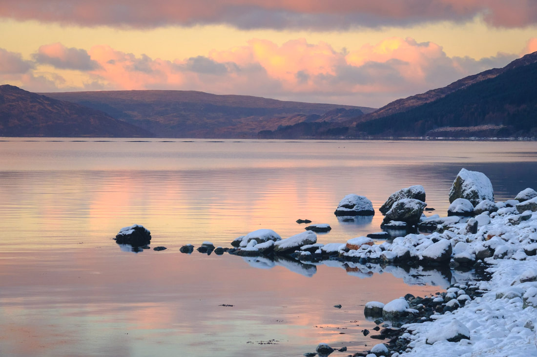
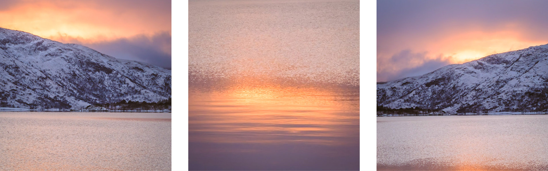
However, the house is in a beautiful spot. One that is simply magical during a winter sunrise, and I was happy to be able to capture a little bit of this magic not long after high tide on the morning of 15 January. The snow had just stopped falling and the sun was beginning to rise above the hills of Morvern on the other side of the loch, bringing with it a lovely combination of pastel pinks and blues that were followed some intense bursts of yellows and golds. 
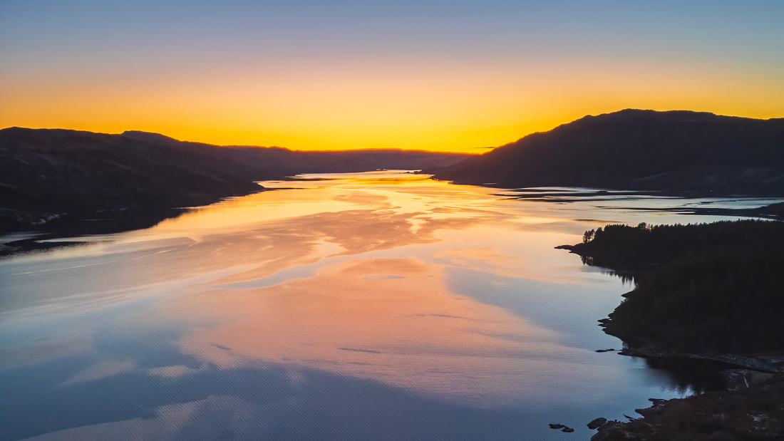
Winter sunsets at the house can be spectacular too, especially on a perfectly clear evenings such as the one shown here when an intense band of yellow filled the western sky and painted the surface of the loch. Although there is no doubting that such sunsets are an amazing sight, I sometimes prefer photographing in the hour after sunset. Called the Blue Hour, it is when the sky transitions to a serene shade of blue and creates a magical and tranquil atmosphere. So, on this particular evening, I turned the drone to face the other way, waited for the blue to appear and took these images. 
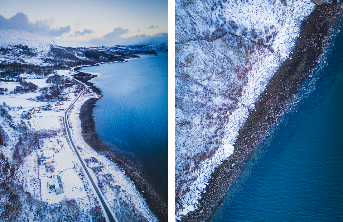
The image on the left shows the settlement of Resipole with the snow-covered flank of Ben Resipole beyond it and a snow fringed Loch Sunart to its right, while the image on the right was taken looking straight down at the contrast between the snow covered oakwoods, the bare boulders of the loch shore and the deep blue of the loch itself.
|
AuthorHi, I’m Steven Marshall, a Scottish landscape photographer based at Rockpool House in the heart of the beautiful West Highland Peninsulas of Sunart, Morvern, Moidart, Ardgour and Ardnamurchan. Categories
All
Archives
December 2024
|